Schlöben geodata
Schlöben (Thuringia) is a seat of a fourth-order administrative division; located in Germany in Europe/Berlin (GMT+2) time zone. With population of 982 people, there are 7245 cities with bigger population in this country. Compared to other cities in Germany, 55.9% of cities are located further ↓South; 77.1% of cities are located further ←West and 52.5% of cities have lower elevation than Schlöben. Note1


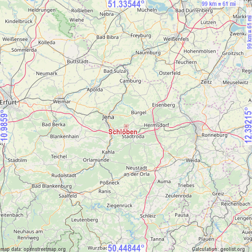
Schlöben GPS coordinates[2]
50° 53' 38.58" North, 11° 41' 20.472" East
| Map corner | latitude | longitude |
|---|---|---|
| Upper-left | 51.33544°, | 10.9859° |
| Center: | 50.89405°, | 11.68902° |
| Lower-right: | 50.44844°, | 12.39215° |
| Map W x H: | 98.6×98.6 km | = 61.3×61.3mi |
| max Lat: | 55.01917° ⇑44.1% North |
| Schlöben: | 50.89405° |
| min Lat: | ⇓55.9% South 47.40724° |
| min Long | Schlöben | max Long |
| 5.92978° | 11.68902° | 14.98853° |
| W 77.1%⇐ | ⇒22.9% E |
Elevation
Elevation of Schlöben is 243 m = 797 ft, and this is 6.1 m = 20 ft below average elevation for this country.
| Max E: |
1256 m = 4121 ft | 47.5% |
| Avg. | 249.1 m = 817 ft | |
| Schlöben | 243 m = 797 ft | |
Min E: |
-5 m = -16 ft | 52.5% |
See also: Germany elevation on elevation.city.
Geographical zone
Schlöben is located in North temperate zone (between Tropic of Cancer and the Arctic Circle). Distance of this North polar circle is 1742.3 km =1082.6 mi to North.| Distance of | km | miles | from Schlöben |
|---|---|---|---|
| North Pole | 4348.2 | 2701.8 | to North |
| Arctic Circle | 1742.3 | 1082.6 | to North |
| Tropic Cancer | 3053 | 1897 | to South |
| Equator | 5658.9 | 3516.3 | to South |


Nearby cities:
15 places around Schlöben: (largest is in red/bold)
• Albersdorf
6 km =3.7 mi,  80°
80°
• Großbockedra
5.6 km =3.5 mi,  209°
209°
• Großlöbichau
3.8 km =2.4 mi,  350°
350°
• Jenalöbnitz
6.3 km =3.9 mi,  7°
7°
• Kleinbockedra
5.6 km =3.5 mi, 209°
• Laasdorf
2.8 km =1.7 mi,  204°
204°
• Quirla
6.2 km =3.9 mi,  119°
119°
• Rausdorf
3.1 km =1.9 mi,  187°
187°
• Ruttersdorf-Lotschen
3.3 km =2.1 mi,  110°
110°
• Scheiditz
4.7 km =2.9 mi,  74°
74°
• Schöngleina
2.9 km =1.8 mi,  58°
58°
• Stadtroda
4.9 km =3 mi,  147°
147°
• Sulza
5.9 km =3.7 mi,  239°
239°
• Tissa
6.5 km =4 mi,  138°
138°
• Zöllnitz
4.1 km =2.5 mi, 235°
Sources, notices
• [Note1] Compared only with cities in Germany existing in our database
• [Src1] Map data: © OpenStreetMap contributors (CC-BY-SA)
• [Src2] Other city data from geonames.org with taken over terms of usage.
• [Src3] Geographical zone / Annual Mean Temperature by Robert A. Rohde @ Wikipedia
