Spornitz geodata
Spornitz (Mecklenburg-Vorpommern) is a populated place; located in Germany in Europe/Berlin (GMT+2) time zone. With population of 1,568 people, there are 5745 cities with bigger population in this country. Compared to other cities in Germany, 84.6% of cities are located further ↓South; 77.5% of cities are located further ←West and 76.4% of cities have higher elevation than Spornitz. Note1
Administrative division(s):
- Level 1: Mecklenburg-Vorpommern
- Level 3: Ludwigslust-Parchim
- Level 4: Spornitz


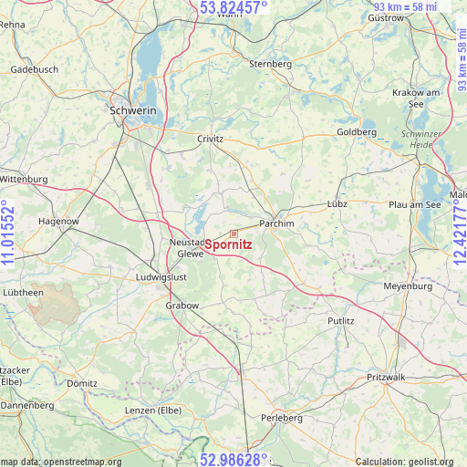
Spornitz GPS coordinates[2]
53° 24' 26.964" North, 11° 43' 7.104" East
| Map corner | latitude | longitude |
|---|---|---|
| Upper-left | 53.82457°, | 11.01552° |
| Center: | 53.40749°, | 11.71864° |
| Lower-right: | 52.98628°, | 12.42177° |
| Map W x H: | 93.2×93.2 km | = 57.9×57.9mi |
| max Lat: | 55.01917° ⇑15.4% North |
| Spornitz: | 53.40749° |
| min Lat: | ⇓84.6% South 47.40724° |
| min Long | Spornitz | max Long |
| 5.92978° | 11.71864° | 14.98853° |
| W 77.5%⇐ | ⇒22.5% E |
Elevation
Elevation of Spornitz is 58 m = 190 ft, and this is 191.1 m = 627 ft below average elevation for this country.
| Max E: |
1256 m = 4121 ft | 76.4% |
| Avg. | 249.1 m = 817 ft | |
| Spornitz | 58 m = 190 ft | |
Min E: |
-5 m = -16 ft | 23.6% |
See also: Germany elevation on elevation.city.
Geographical zone
Spornitz is located in North temperate zone (between Tropic of Cancer and the Arctic Circle). Distance of this North polar circle is 1462.8 km =908.9 mi to North.| Distance of | km | miles | from Spornitz |
|---|---|---|---|
| North Pole | 4068.7 | 2528.2 | to North |
| Arctic Circle | 1462.8 | 908.9 | to North |
| Tropic Cancer | 3332.4 | 2070.7 | to South |
| Equator | 5938.4 | 3689.9 | to South |


Nearby cities:
15 places around Spornitz: (largest is in red/bold)
• Blievenstorf
6.2 km =3.9 mi,  214°
214°
• Brenz
4.4 km =2.7 mi,  232°
232°
• Damm
4.3 km =2.7 mi,  33°
33°
• Domsühl
9.5 km =5.9 mi,  21°
21°
• Friedrichsruhe
13.5 km =8.4 mi,  9°
9°
• Groß Laasch
13.1 km =8.1 mi,  238°
238°
• Löcknitz
14 km =8.7 mi,  162°
162°
• Matzlow-Garwitz
4.5 km =2.8 mi,  348°
348°
• Neuburg
13.2 km =8.2 mi,  90°
90°
• Neustadt-Glewe
9 km =5.6 mi,  248°
248°
• Parchim
8.9 km =5.5 mi,  76°
76°
• Raduhn
8.5 km =5.3 mi,  344°
344°
• Tramm
13.6 km =8.5 mi, 339°
• Wöbbelin
14.4 km =8.9 mi,  267°
267°
• Ziegendorf
13.9 km =8.6 mi,  152°
152°
Sources, notices
• [Note1] Compared only with cities in Germany existing in our database
• [Src1] Map data: © OpenStreetMap contributors (CC-BY-SA)
• [Src2] Other city data from geonames.org with taken over terms of usage.
• [Src3] Geographical zone / Annual Mean Temperature by Robert A. Rohde @ Wikipedia
