Ziegendorf geodata
Ziegendorf (Mecklenburg-Vorpommern) is a populated place; located in Germany in Europe/Berlin (GMT+2) time zone. With population of 792 people, there are 7930 cities with bigger population in this country. Compared to other cities in Germany, 83.6% of cities are located further ↓South; 79% of cities are located further ←West and 80.6% of cities have higher elevation than Ziegendorf. Note1
Administrative division(s):
- Level 1: Mecklenburg-Vorpommern
- Level 3: Ludwigslust-Parchim
- Level 4: Ziegendorf


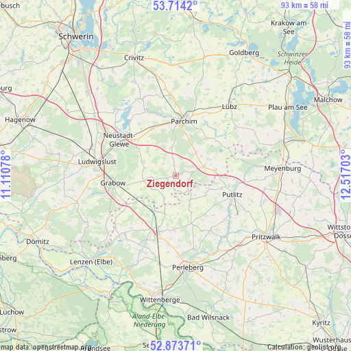
Ziegendorf GPS coordinates[2]
53° 17' 45.672" North, 11° 48' 50.04" East
| Map corner | latitude | longitude |
|---|---|---|
| Upper-left | 53.7142°, | 11.11078° |
| Center: | 53.29602°, | 11.8139° |
| Lower-right: | 52.87371°, | 12.51703° |
| Map W x H: | 93.5×93.5 km | = 58.1×58.1mi |
| max Lat: | 55.01917° ⇑16.4% North |
| Ziegendorf: | 53.29602° |
| min Lat: | ⇓83.6% South 47.40724° |
| min Long | Ziegendorf | max Long |
| 5.92978° | 11.8139° | 14.98853° |
| W 79%⇐ | ⇒21% E |
Elevation
Elevation of Ziegendorf is 45 m = 148 ft, and this is 204.1 m = 670 ft below average elevation for this country.
| Max E: |
1256 m = 4121 ft | 80.6% |
| Avg. | 249.1 m = 817 ft | |
| Ziegendorf | 45 m = 148 ft | |
Min E: |
-5 m = -16 ft | 19.4% |
See also: Germany elevation on elevation.city.
Geographical zone
Ziegendorf is located in North temperate zone (between Tropic of Cancer and the Arctic Circle). Distance of this North polar circle is 1475.2 km =916.6 mi to North.| Distance of | km | miles | from Ziegendorf |
|---|---|---|---|
| North Pole | 4081.1 | 2535.9 | to North |
| Arctic Circle | 1475.2 | 916.6 | to North |
| Tropic Cancer | 3320 | 2063 | to South |
| Equator | 5926 | 3682.2 | to South |


Nearby cities:
15 places around Ziegendorf: (largest is in red/bold)
• Berge
7.8 km =4.8 mi,  153°
153°
• Blievenstorf
12.3 km =7.6 mi,  306°
306°
• Brenz
13.8 km =8.6 mi, 314°
• Damm
16.5 km =10.3 mi,  346°
346°
• Grabow
16.6 km =10.3 mi,  263°
263°
• Karstädt
15.6 km =9.7 mi,  197°
197°
• Löcknitz
2.4 km =1.5 mi,  245°
245°
• Marnitz
8 km =5 mi,  73°
73°
• Neuburg
14.1 km =8.8 mi,  29°
29°
• Parchim
14.7 km =9.1 mi,  9°
9°
• Pirow
10.5 km =6.5 mi, 147°
• Prislich
13 km =8.1 mi, 258°
• Putlitz
16 km =9.9 mi,  109°
109°
• Siggelkow
13.1 km =8.1 mi,  39°
39°
• Spornitz
13.9 km =8.6 mi,  332°
332°
Sources, notices
• [Note1] Compared only with cities in Germany existing in our database
• [Src1] Map data: © OpenStreetMap contributors (CC-BY-SA)
• [Src2] Other city data from geonames.org with taken over terms of usage.
• [Src3] Geographical zone / Annual Mean Temperature by Robert A. Rohde @ Wikipedia
