Sonsbeck geodata
Sonsbeck (North Rhine-Westphalia) is a seat of a fourth-order administrative division; located in Germany in Europe/Berlin (GMT+2) time zone. With population of 8,604 people, there are 1856 cities with bigger population in this country. Compared to other cities in Germany, 67.7% of cities are located further ↓South; 98.7% of cities are located further →East and 88.6% of cities have higher elevation than Sonsbeck. Note1
Administrative division(s):
- Level 1: North Rhine-Westphalia
- Level 2: Düsseldorf District
- Level 3: Kreis Wesel
- Level 4: Sonsbeck


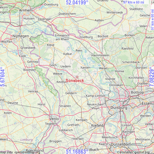
Sonsbeck GPS coordinates[2]
51° 36' 26.676" North, 6° 22' 44.976" East
| Map corner | latitude | longitude |
|---|---|---|
| Upper-left | 52.04199°, | 5.67604° |
| Center: | 51.60741°, | 6.37916° |
| Lower-right: | 51.16863°, | 7.08229° |
| Map W x H: | 97.1×97.1 km | = 60.3×60.3mi |
| max Lat: | 55.01917° ⇑32.3% North |
| Sonsbeck: | 51.60741° |
| min Lat: | ⇓67.7% South 47.40724° |
| min Long | Sonsbeck | max Long |
| 5.92978° | 6.37916° | 14.98853° |
| W 1.3%⇐ | ⇒98.7% E |
Elevation
Elevation of Sonsbeck is 25 m = 82 ft, and this is 224.1 m = 735 ft below average elevation for this country.
| Max E: |
1256 m = 4121 ft | 88.6% |
| Avg. | 249.1 m = 817 ft | |
| Sonsbeck | 25 m = 82 ft | |
Min E: |
-5 m = -16 ft | 11.4% |
See also: Germany elevation on elevation.city.
Geographical zone
Sonsbeck is located in North temperate zone (between Tropic of Cancer and the Arctic Circle). Distance of this North polar circle is 1663 km =1033.3 mi to North.| Distance of | km | miles | from Sonsbeck |
|---|---|---|---|
| North Pole | 4268.9 | 2652.6 | to North |
| Arctic Circle | 1663 | 1033.3 | to North |
| Tropic Cancer | 3132.3 | 1946.3 | to South |
| Equator | 5738.2 | 3565.6 | to South |


Nearby cities:
15 places around Sonsbeck: (largest is in red/bold)
• Alpen
9.9 km =6.2 mi,  105°
105°
• Geldern
10.5 km =6.5 mi,  201°
201°
• Goch
17.1 km =10.6 mi,  297°
297°
• Issum
9 km =5.6 mi,  155°
155°
• Kalkar
15.9 km =9.9 mi,  337°
337°
• Kamp-Lintfort
16.2 km =10.1 mi,  134°
134°
• Kevelaer
9.6 km =6 mi,  253°
253°
• Mehrhoog
17.2 km =10.7 mi,  32°
32°
• Rees
17.3 km =10.7 mi,  4°
4°
• Rheinberg
16.4 km =10.2 mi, 114°
• Rheurdt
16.8 km =10.4 mi, 158°
• Uedem
9.7 km =6 mi,  311°
311°
• Weeze
12.7 km =7.9 mi,  279°
279°
• Wemb
14.2 km =8.8 mi,  260°
260°
• Xanten
7.7 km =4.8 mi,  41°
41°
Sources, notices
• [Note1] Compared only with cities in Germany existing in our database
• [Src1] Map data: © OpenStreetMap contributors (CC-BY-SA)
• [Src2] Other city data from geonames.org with taken over terms of usage.
• [Src3] Geographical zone / Annual Mean Temperature by Robert A. Rohde @ Wikipedia
