Kevelaer geodata
Kevelaer (North Rhine-Westphalia) is a populated place; located in Germany in Europe/Berlin (GMT+2) time zone. With population of 28,064 people, there are 504 cities with bigger population in this country. Compared to other cities in Germany, 67.3% of cities are located further ↓South; 99.5% of cities are located further →East and 88.6% of cities have higher elevation than Kevelaer. Note1
Administrative division(s):
- Level 1: North Rhine-Westphalia
- Level 2: Düsseldorf District
- Level 3: Kreis Kleve
- Level 4: Kevelaer


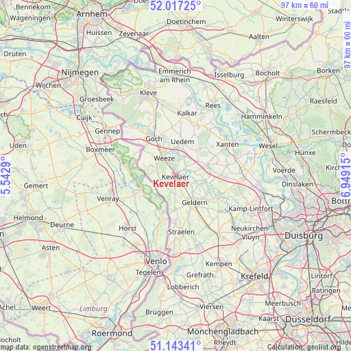
Kevelaer GPS coordinates[2]
51° 34' 56.748" North, 6° 14' 45.708" East
| Map corner | latitude | longitude |
|---|---|---|
| Upper-left | 52.01725°, | 5.5429° |
| Center: | 51.58243°, | 6.24603° |
| Lower-right: | 51.14341°, | 6.94915° |
| Map W x H: | 97.2×97.2 km | = 60.4×60.4mi |
| max Lat: | 55.01917° ⇑32.7% North |
| Kevelaer: | 51.58243° |
| min Lat: | ⇓67.3% South 47.40724° |
| min Long | Kevelaer | max Long |
| 5.92978° | 6.24603° | 14.98853° |
| W 0.5%⇐ | ⇒99.5% E |
Elevation
Elevation of Kevelaer is 25 m = 82 ft, and this is 224.1 m = 735 ft below average elevation for this country.
| Max E: |
1256 m = 4121 ft | 88.6% |
| Avg. | 249.1 m = 817 ft | |
| Kevelaer | 25 m = 82 ft | |
Min E: |
-5 m = -16 ft | 11.4% |
See also: Germany elevation on elevation.city.
Geographical zone
Kevelaer is located in North temperate zone (between Tropic of Cancer and the Arctic Circle). Distance of this North polar circle is 1665.7 km =1035 mi to North.| Distance of | km | miles | from Kevelaer |
|---|---|---|---|
| North Pole | 4271.6 | 2654.2 | to North |
| Arctic Circle | 1665.7 | 1035 | to North |
| Tropic Cancer | 3129.5 | 1944.6 | to South |
| Equator | 5735.4 | 3563.8 | to South |


Nearby cities:
15 places around Kevelaer: (largest is in red/bold)
• Alpen
18.7 km =11.6 mi,  89°
89°
• Geldern
8.9 km =5.5 mi,  142°
142°
• Goch
12.3 km =7.6 mi,  330°
330°
• Issum
14.1 km =8.8 mi,  112°
112°
• Kalkar
17.7 km =11 mi,  10°
10°
• Kamp-Lintfort
22.5 km =14 mi, 112°
• Rees
22.6 km =14 mi,  27°
27°
• Rheurdt
20 km =12.4 mi,  130°
130°
• Sonsbeck
9.6 km =6 mi,  73°
73°
• Straelen
15.7 km =9.8 mi,  174°
174°
• Uedem
9.4 km =5.8 mi, 11°
• Wachtendonk
20.3 km =12.6 mi,  161°
161°
• Weeze
5.9 km =3.7 mi, 326°
• Wemb
4.8 km =3 mi,  275°
275°
• Xanten
16.6 km =10.3 mi,  59°
59°
Sources, notices
• [Note1] Compared only with cities in Germany existing in our database
• [Src1] Map data: © OpenStreetMap contributors (CC-BY-SA)
• [Src2] Other city data from geonames.org with taken over terms of usage.
• [Src3] Geographical zone / Annual Mean Temperature by Robert A. Rohde @ Wikipedia
