Xanten geodata
Xanten (North Rhine-Westphalia) is a populated place; located in Germany in Europe/Berlin (GMT+2) time zone. With population of 21,587 people, there are 700 cities with bigger population in this country. Compared to other cities in Germany, 68.4% of cities are located further ↓South; 98.1% of cities are located further →East and 88.9% of cities have higher elevation than Xanten. Note1
Administrative division(s):
- Level 1: North Rhine-Westphalia
- Level 2: Düsseldorf District
- Level 3: Kreis Wesel
- Level 4: Xanten


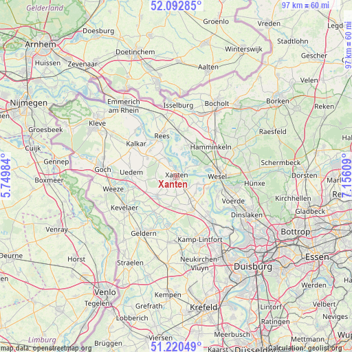
Xanten GPS coordinates[2]
51° 39' 31.572" North, 6° 27' 10.692" East
| Map corner | latitude | longitude |
|---|---|---|
| Upper-left | 52.09285°, | 5.74984° |
| Center: | 51.65877°, | 6.45297° |
| Lower-right: | 51.22049°, | 7.15609° |
| Map W x H: | 97×97 km | = 60.3×60.3mi |
| max Lat: | 55.01917° ⇑31.6% North |
| Xanten: | 51.65877° |
| min Lat: | ⇓68.4% South 47.40724° |
| min Long | Xanten | max Long |
| 5.92978° | 6.45297° | 14.98853° |
| W 1.9%⇐ | ⇒98.1% E |
Elevation
Elevation of Xanten is 24 m = 79 ft, and this is 225.1 m = 739 ft below average elevation for this country.
| Max E: |
1256 m = 4121 ft | 88.9% |
| Avg. | 249.1 m = 817 ft | |
| Xanten | 24 m = 79 ft | |
Min E: |
-5 m = -16 ft | 11.1% |
See also: Germany elevation on elevation.city.
Geographical zone
Xanten is located in North temperate zone (between Tropic of Cancer and the Arctic Circle). Distance of this North polar circle is 1657.3 km =1029.8 mi to North.| Distance of | km | miles | from Xanten |
|---|---|---|---|
| North Pole | 4263.1 | 2649 | to North |
| Arctic Circle | 1657.3 | 1029.8 | to North |
| Tropic Cancer | 3138 | 1949.9 | to South |
| Equator | 5743.9 | 3569.1 | to South |


Nearby cities:
15 places around Xanten: (largest is in red/bold)
• Alpen
9.5 km =5.9 mi,  152°
152°
• Geldern
17.9 km =11.1 mi,  209°
209°
• Hamminkeln
12.5 km =7.8 mi,  49°
49°
• Hünxe
17.1 km =10.6 mi,  99°
99°
• Issum
14 km =8.7 mi,  185°
185°
• Kalkar
14.3 km =8.9 mi,  308°
308°
• Kevelaer
16.6 km =10.3 mi,  239°
239°
• Mehrhoog
9.7 km =6 mi,  24°
24°
• Rees
12.2 km =7.6 mi,  341°
341°
• Rheinberg
15.9 km =9.9 mi,  141°
141°
• Sonsbeck
7.7 km =4.8 mi,  221°
221°
• Uedem
12.4 km =7.7 mi,  273°
273°
• Voerde
17.5 km =10.9 mi,  113°
113°
• Weeze
18 km =11.2 mi,  258°
258°
• Wesel
11.6 km =7.2 mi,  85°
85°
Sources, notices
• [Note1] Compared only with cities in Germany existing in our database
• [Src1] Map data: © OpenStreetMap contributors (CC-BY-SA)
• [Src2] Other city data from geonames.org with taken over terms of usage.
• [Src3] Geographical zone / Annual Mean Temperature by Robert A. Rohde @ Wikipedia
