Sonderhofen geodata
Sonderhofen (Bavaria) is a seat of a fourth-order administrative division; located in Germany in Europe/Berlin (GMT+2) time zone. With population of 826 people, there are 7794 cities with bigger population in this country. Compared to other cities in Germany, 73.9% of cities are located further ↑North; 50.1% of cities are located further ←West and 60% of cities have lower elevation than Sonderhofen. Note1
Administrative division(s):
- Level 1: Bavaria
- Level 2: Regierungsbezirk Unterfranken
- Level 3: Landkreis Würzburg
- Level 4: Sonderhofen


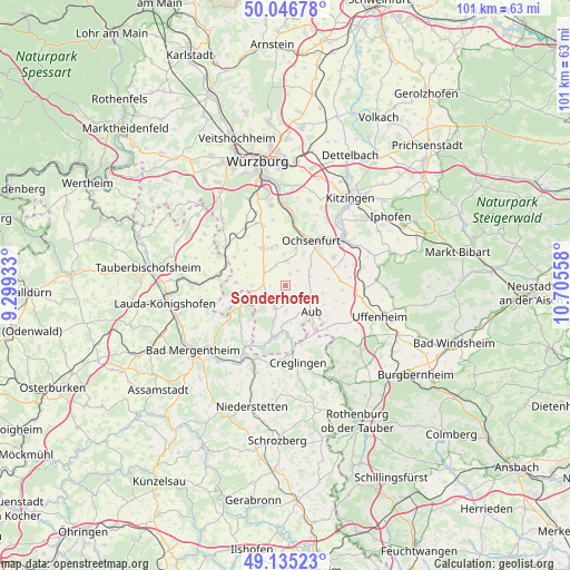
Sonderhofen GPS coordinates[2]
49° 35' 35.268" North, 10° 0' 8.82" East
| Map corner | latitude | longitude |
|---|---|---|
| Upper-left | 50.04678°, | 9.29933° |
| Center: | 49.59313°, | 10.00245° |
| Lower-right: | 49.13523°, | 10.70558° |
| Map W x H: | 101.4×101.4 km | = 63×63mi |
| max Lat: | 55.01917° ⇑73.9% North |
| Sonderhofen: | 49.59313° |
| min Lat: | ⇓26.1% South 47.40724° |
| min Long | Sonderhofen | max Long |
| 5.92978° | 10.00245° | 14.98853° |
| W 50.1%⇐ | ⇒49.9% E |
Elevation
Elevation of Sonderhofen is 290 m = 951 ft, and this is 40.9 m = 134 ft above average elevation for this country.
| Max E: |
1256 m = 4121 ft | 40% |
| Sonderhofen | 290 m 951 ft | |
| Avg. | 249.1 m = 817 ft | |
Min E: |
-5 m = -16 ft | 60% |
See also: Germany elevation on elevation.city.
Geographical zone
Sonderhofen is located in North temperate zone (between Tropic of Cancer and the Arctic Circle). Distance of this North polar circle is 1886.9 km =1172.5 mi to North.| Distance of | km | miles | from Sonderhofen |
|---|---|---|---|
| North Pole | 4492.8 | 2791.7 | to North |
| Arctic Circle | 1886.9 | 1172.5 | to North |
| Tropic Cancer | 2908.3 | 1807.1 | to South |
| Equator | 5514.2 | 3426.4 | to South |


Nearby cities:
15 places around Sonderhofen: (largest is in red/bold)
• Aub
6.4 km =4 mi,  134°
134°
• Bieberehren
8.4 km =5.2 mi,  176°
176°
• Bütthard
8.9 km =5.5 mi,  274°
274°
• Frickenhausen
10.8 km =6.7 mi,  36°
36°
• Gaukönigshofen
4.5 km =2.8 mi,  357°
357°
• Gelchsheim
2.6 km =1.6 mi,  151°
151°
• Giebelstadt
7.9 km =4.9 mi,  327°
327°
• Hemmersheim
7.6 km =4.7 mi,  116°
116°
• Martinsheim
11.1 km =6.9 mi,  72°
72°
• Oberickelsheim
9.5 km =5.9 mi,  85°
85°
• Ochsenfurt
9 km =5.6 mi,  28°
28°
• Riedenheim
4.4 km =2.7 mi,  203°
203°
• Röttingen
9.6 km =6 mi,  193°
193°
• Simmershofen
11.5 km =7.1 mi, 125°
• Sulzdorf
9.5 km =5.9 mi,  311°
311°
Sources, notices
• [Note1] Compared only with cities in Germany existing in our database
• [Src1] Map data: © OpenStreetMap contributors (CC-BY-SA)
• [Src2] Other city data from geonames.org with taken over terms of usage.
• [Src3] Geographical zone / Annual Mean Temperature by Robert A. Rohde @ Wikipedia
