Bütthard geodata
Bütthard (Bavaria) is a populated place; located in Germany in Europe/Berlin (GMT+2) time zone. With population of 1,300 people, there are 6307 cities with bigger population in this country. Compared to other cities in Germany, 73.9% of cities are located further ↑North; 51.8% of cities are located further →East and 59.3% of cities have lower elevation than Bütthard. Note1
Administrative division(s):
- Level 1: Bavaria
- Level 2: Regierungsbezirk Unterfranken
- Level 3: Landkreis Würzburg
- Level 4: Bütthard, Markt


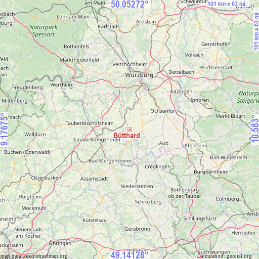
Bütthard GPS coordinates[2]
49° 35' 56.868" North, 9° 52' 47.532" East
| Map corner | latitude | longitude |
|---|---|---|
| Upper-left | 50.05272°, | 9.17675° |
| Center: | 49.59913°, | 9.87987° |
| Lower-right: | 49.14128°, | 10.583° |
| Map W x H: | 101.3×101.3 km | = 62.9×62.9mi |
| max Lat: | 55.01917° ⇑73.9% North |
| Bütthard: | 49.59913° |
| min Lat: | ⇓26.1% South 47.40724° |
| min Long | Bütthard | max Long |
| 5.92978° | 9.87987° | 14.98853° |
| W 48.2%⇐ | ⇒51.8% E |
Elevation
Elevation of Bütthard is 285 m = 935 ft, and this is 35.9 m = 118 ft above average elevation for this country.
| Max E: |
1256 m = 4121 ft | 40.7% |
| Bütthard | 285 m 935 ft | |
| Avg. | 249.1 m = 817 ft | |
Min E: |
-5 m = -16 ft | 59.3% |
See also: Germany elevation on elevation.city.
Geographical zone
Bütthard is located in North temperate zone (between Tropic of Cancer and the Arctic Circle). Distance of this North polar circle is 1886.3 km =1172.1 mi to North.| Distance of | km | miles | from Bütthard |
|---|---|---|---|
| North Pole | 4492.2 | 2791.3 | to North |
| Arctic Circle | 1886.3 | 1172.1 | to North |
| Tropic Cancer | 2909 | 1807.6 | to South |
| Equator | 5514.9 | 3426.8 | to South |


Nearby cities:
15 places around Bütthard: (largest is in red/bold)
• Gaukönigshofen
9.5 km =5.9 mi,  66°
66°
• Gelchsheim
10.5 km =6.5 mi,  106°
106°
• Geroldshausen
9.5 km =5.9 mi,  9°
9°
• Giebelstadt
7.6 km =4.7 mi,  37°
37°
• Großrinderfeld
12.9 km =8 mi,  304°
304°
• Grünsfeld
9.6 km =6 mi,  276°
276°
• Igersheim
12.5 km =7.8 mi,  201°
201°
• Kirchheim
6.5 km =4 mi,  345°
345°
• Kleinrinderfeld
11.5 km =7.1 mi, 347°
• Lauda-Königshofen
12.9 km =8 mi,  253°
253°
• Riedenheim
8.5 km =5.3 mi,  123°
123°
• Röttingen
11.9 km =7.4 mi,  146°
146°
• Sonderhofen
8.9 km =5.5 mi,  94°
94°
• Sulzdorf
5.9 km =3.7 mi,  17°
17°
• Tauberrettersheim
12.3 km =7.6 mi,  160°
160°
Sources, notices
• [Note1] Compared only with cities in Germany existing in our database
• [Src1] Map data: © OpenStreetMap contributors (CC-BY-SA)
• [Src2] Other city data from geonames.org with taken over terms of usage.
• [Src3] Geographical zone / Annual Mean Temperature by Robert A. Rohde @ Wikipedia
