Sensweiler geodata
Sensweiler (Rheinland-Pfalz) is a seat of a fourth-order administrative division; located in Germany in Europe/Berlin (GMT+2) time zone. With population of 553 people, there are 9064 cities with bigger population in this country. Compared to other cities in Germany, 69.5% of cities are located further ↑North; 91.4% of cities are located further →East and 89.8% of cities have lower elevation than Sensweiler. Note1
Administrative division(s):
- Level 1: Rheinland-Pfalz
- Level 3: Landkreis Birkenfeld
- Level 4: Sensweiler


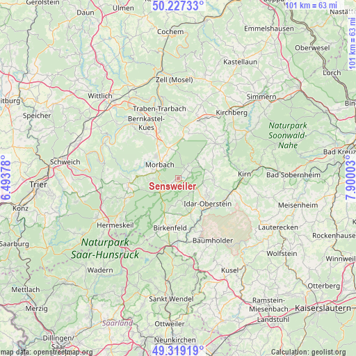
Sensweiler GPS coordinates[2]
49° 46' 31.404" North, 7° 11' 48.84" East
| Map corner | latitude | longitude |
|---|---|---|
| Upper-left | 50.22733°, | 6.49378° |
| Center: | 49.77539°, | 7.1969° |
| Lower-right: | 49.31919°, | 7.90003° |
| Map W x H: | 101×101 km | = 62.8×62.8mi |
| max Lat: | 55.01917° ⇑69.5% North |
| Sensweiler: | 49.77539° |
| min Lat: | ⇓30.5% South 47.40724° |
| min Long | Sensweiler | max Long |
| 5.92978° | 7.1969° | 14.98853° |
| W 8.6%⇐ | ⇒91.4% E |
Elevation
Elevation of Sensweiler is 511 m = 1677 ft, and this is 261.9 m = 859 ft above average elevation for this country.
| Max E: |
1256 m = 4121 ft | 10.2% |
| Sensweiler | 511 m 1677 ft | |
| Avg. | 249.1 m = 817 ft | |
Min E: |
-5 m = -16 ft | 89.8% |
See also: Germany elevation on elevation.city.
Geographical zone
Sensweiler is located in North temperate zone (between Tropic of Cancer and the Arctic Circle). Distance of this North polar circle is 1866.7 km =1159.9 mi to North.| Distance of | km | miles | from Sensweiler |
|---|---|---|---|
| North Pole | 4472.6 | 2779.1 | to North |
| Arctic Circle | 1866.7 | 1159.9 | to North |
| Tropic Cancer | 2928.6 | 1819.7 | to South |
| Equator | 5534.5 | 3439 | to South |


Nearby cities:
15 places around Sensweiler: (largest is in red/bold)
• Allenbach
3.2 km =2 mi,  222°
222°
• Asbach
7.7 km =4.8 mi,  53°
53°
• Bruchweiler
3.3 km =2.1 mi,  38°
38°
• Hellertshausen
7.7 km =4.8 mi, 53°
• Herborn
7.5 km =4.7 mi,  97°
97°
• Hettenrodt
5.7 km =3.5 mi,  133°
133°
• Kempfeld
3.9 km =2.4 mi,  65°
65°
• Kirschweiler
4.7 km =2.9 mi, 126°
• Langweiler
1.3 km =0.8 mi,  312°
312°
• Leisel
6.5 km =4 mi,  178°
178°
• Mackenrodt
7.6 km =4.7 mi,  149°
149°
• Morbach
6.2 km =3.9 mi, 305°
• Schauren
4.6 km =2.9 mi, 39°
• Siesbach
5.4 km =3.4 mi, 150°
• Wirschweiler
2.4 km =1.5 mi,  245°
245°
Sources, notices
• [Note1] Compared only with cities in Germany existing in our database
• [Src1] Map data: © OpenStreetMap contributors (CC-BY-SA)
• [Src2] Other city data from geonames.org with taken over terms of usage.
• [Src3] Geographical zone / Annual Mean Temperature by Robert A. Rohde @ Wikipedia
