Bruchweiler geodata
Bruchweiler (Rheinland-Pfalz) is a seat of a fourth-order administrative division; located in Germany in Europe/Berlin (GMT+2) time zone. With population of 550 people, there are 9080 cities with bigger population in this country. Compared to other cities in Germany, 69.1% of cities are located further ↑North; 91.1% of cities are located further →East and 92.1% of cities have lower elevation than Bruchweiler. Note1
Administrative division(s):
- Level 1: Rheinland-Pfalz
- Level 3: Landkreis Birkenfeld
- Level 4: Bruchweiler


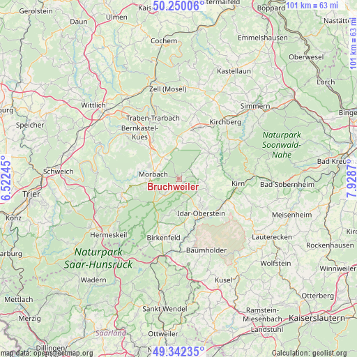
Bruchweiler GPS coordinates[2]
49° 47' 53.988" North, 7° 13' 32.052" East
| Map corner | latitude | longitude |
|---|---|---|
| Upper-left | 50.25006°, | 6.52245° |
| Center: | 49.79833°, | 7.22557° |
| Lower-right: | 49.34235°, | 7.9287° |
| Map W x H: | 100.9×100.9 km | = 62.7×62.7mi |
| max Lat: | 55.01917° ⇑69.1% North |
| Bruchweiler: | 49.79833° |
| min Lat: | ⇓30.9% South 47.40724° |
| min Long | Bruchweiler | max Long |
| 5.92978° | 7.22557° | 14.98853° |
| W 8.9%⇐ | ⇒91.1% E |
Elevation
Elevation of Bruchweiler is 544 m = 1785 ft, and this is 294.9 m = 968 ft above average elevation for this country.
| Max E: |
1256 m = 4121 ft | 7.9% |
| Bruchweiler | 544 m 1785 ft | |
| Avg. | 249.1 m = 817 ft | |
Min E: |
-5 m = -16 ft | 92.1% |
See also: Germany elevation on elevation.city.
Geographical zone
Bruchweiler is located in North temperate zone (between Tropic of Cancer and the Arctic Circle). Distance of this North polar circle is 1864.1 km =1158.3 mi to North.| Distance of | km | miles | from Bruchweiler |
|---|---|---|---|
| North Pole | 4470 | 2777.5 | to North |
| Arctic Circle | 1864.1 | 1158.3 | to North |
| Tropic Cancer | 2931.1 | 1821.3 | to South |
| Equator | 5537.1 | 3440.6 | to South |


Nearby cities:
15 places around Bruchweiler: (largest is in red/bold)
• Allenbach
6.4 km =4 mi,  220°
220°
• Asbach
4.6 km =2.9 mi,  63°
63°
• Hellertshausen
4.6 km =2.9 mi, 63°
• Herborn
6.4 km =4 mi,  123°
123°
• Hettenrodt
6.8 km =4.2 mi,  162°
162°
• Hottenbach
6 km =3.7 mi, 60°
• Kempfeld
1.8 km =1.1 mi, 122°
• Kirschweiler
5.7 km =3.5 mi, 161°
• Langweiler
3.5 km =2.2 mi,  241°
241°
• Mörschied
5.8 km =3.6 mi,  101°
101°
• Oberwörresbach
6.7 km =4.2 mi, 104°
• Schauren
1.3 km =0.8 mi,  40°
40°
• Sensweiler
3.3 km =2.1 mi, 218°
• Weiden
5.7 km =3.5 mi,  69°
69°
• Wirschweiler
5.5 km =3.4 mi,  230°
230°
Sources, notices
• [Note1] Compared only with cities in Germany existing in our database
• [Src1] Map data: © OpenStreetMap contributors (CC-BY-SA)
• [Src2] Other city data from geonames.org with taken over terms of usage.
• [Src3] Geographical zone / Annual Mean Temperature by Robert A. Rohde @ Wikipedia
