Asbach geodata
Asbach (Rheinland-Pfalz) is a seat of a fourth-order administrative division; located in Germany in Europe/Berlin (GMT+2) time zone. With population of 191 people, there are 10512 cities with bigger population in this country. Compared to other cities in Germany, 68.6% of cities are located further ↑North; 90.3% of cities are located further →East and 79.1% of cities have lower elevation than Asbach. Note1


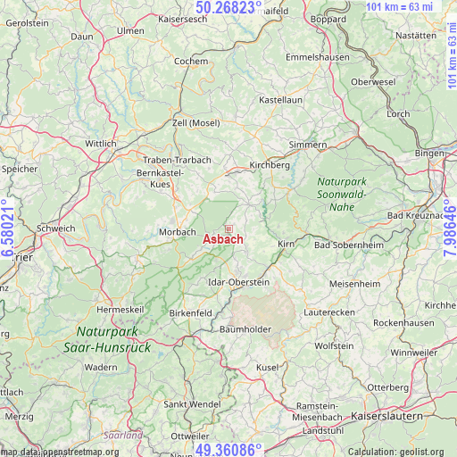
Asbach GPS coordinates[2]
49° 49' 0.012" North, 7° 16' 59.988" East
| Map corner | latitude | longitude |
|---|---|---|
| Upper-left | 50.26823°, | 6.58021° |
| Center: | 49.81667°, | 7.28333° |
| Lower-right: | 49.36086°, | 7.98646° |
| Map W x H: | 100.9×100.9 km | = 62.7×62.7mi |
| max Lat: | 55.01917° ⇑68.6% North |
| Asbach: | 49.81667° |
| min Lat: | ⇓31.4% South 47.40724° |
| min Long | Asbach | max Long |
| 5.92978° | 7.28333° | 14.98853° |
| W 9.7%⇐ | ⇒90.3% E |
Elevation
Elevation of Asbach is 428 m = 1404 ft, and this is 178.9 m = 587 ft above average elevation for this country.
| Max E: |
1256 m = 4121 ft | 20.9% |
| Asbach | 428 m 1404 ft | |
| Avg. | 249.1 m = 817 ft | |
Min E: |
-5 m = -16 ft | 79.1% |
See also: Germany elevation on elevation.city.
Geographical zone
Asbach is located in North temperate zone (between Tropic of Cancer and the Arctic Circle). Distance of this North polar circle is 1862.1 km =1157.1 mi to North.| Distance of | km | miles | from Asbach |
|---|---|---|---|
| North Pole | 4468 | 2776.3 | to North |
| Arctic Circle | 1862.1 | 1157.1 | to North |
| Tropic Cancer | 2933.2 | 1822.6 | to South |
| Equator | 5539.1 | 3441.8 | to South |


Nearby cities:
15 places around Asbach: (largest is in red/bold)
• Bollenbach
5.1 km =3.2 mi,  68°
68°
• Breitenthal
4 km =2.5 mi,  117°
117°
• Bruchweiler
4.6 km =2.9 mi,  243°
243°
• Hellertshausen
0 km =0 mi,  0°
0°
• Herrstein
5.2 km =3.2 mi,  135°
135°
• Hottenbach
1.4 km =0.9 mi,  48°
48°
• Kempfeld
4 km =2.5 mi,  221°
221°
• Mörschied
3.5 km =2.2 mi,  154°
154°
• Oberhosenbach
3.6 km =2.2 mi,  90°
90°
• Oberwörresbach
4.4 km =2.7 mi, 147°
• Schauren
3.5 km =2.2 mi,  252°
252°
• Stipshausen
3.7 km =2.3 mi, 0°
• Sulzbach
4 km =2.5 mi,  62°
62°
• Weiden
1.2 km =0.7 mi, 90°
• Wickenrodt
4.8 km =3 mi, 90°
Sources, notices
• [Note1] Compared only with cities in Germany existing in our database
• [Src1] Map data: © OpenStreetMap contributors (CC-BY-SA)
• [Src2] Other city data from geonames.org with taken over terms of usage.
• [Src3] Geographical zone / Annual Mean Temperature by Robert A. Rohde @ Wikipedia
