Schauren geodata
Schauren (Rheinland-Pfalz) is a seat of a fourth-order administrative division; located in Germany in Europe/Berlin (GMT+2) time zone. With population of 547 people, there are 9098 cities with bigger population in this country. Compared to other cities in Germany, 68.8% of cities are located further ↑North; 90.8% of cities are located further →East and 90.6% of cities have lower elevation than Schauren. Note1
Administrative division(s):
- Level 1: Rheinland-Pfalz
- Level 3: Landkreis Birkenfeld
- Level 4: Schauren


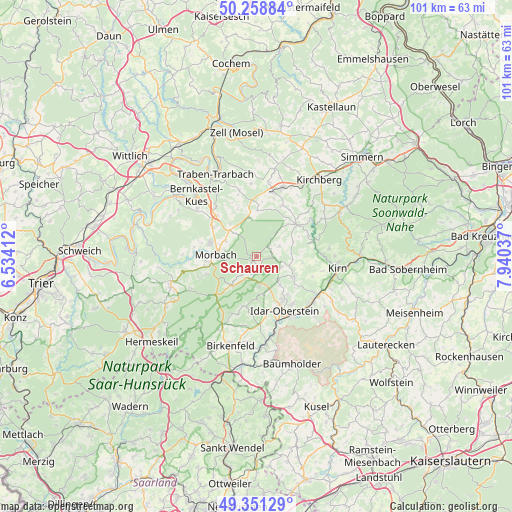
Schauren GPS coordinates[2]
49° 48' 25.884" North, 7° 14' 14.064" East
| Map corner | latitude | longitude |
|---|---|---|
| Upper-left | 50.25884°, | 6.53412° |
| Center: | 49.80719°, | 7.23724° |
| Lower-right: | 49.35129°, | 7.94037° |
| Map W x H: | 100.9×100.9 km | = 62.7×62.7mi |
| max Lat: | 55.01917° ⇑68.8% North |
| Schauren: | 49.80719° |
| min Lat: | ⇓31.2% South 47.40724° |
| min Long | Schauren | max Long |
| 5.92978° | 7.23724° | 14.98853° |
| W 9.2%⇐ | ⇒90.8% E |
Elevation
Elevation of Schauren is 522 m = 1713 ft, and this is 272.9 m = 895 ft above average elevation for this country.
| Max E: |
1256 m = 4121 ft | 9.4% |
| Schauren | 522 m 1713 ft | |
| Avg. | 249.1 m = 817 ft | |
Min E: |
-5 m = -16 ft | 90.6% |
See also: Germany elevation on elevation.city.
Geographical zone
Schauren is located in North temperate zone (between Tropic of Cancer and the Arctic Circle). Distance of this North polar circle is 1863.1 km =1157.7 mi to North.| Distance of | km | miles | from Schauren |
|---|---|---|---|
| North Pole | 4469 | 2776.9 | to North |
| Arctic Circle | 1863.1 | 1157.7 | to North |
| Tropic Cancer | 2932.1 | 1821.9 | to South |
| Equator | 5538 | 3441.2 | to South |


Nearby cities:
15 places around Schauren: (largest is in red/bold)
• Asbach
3.5 km =2.2 mi,  72°
72°
• Breitenthal
6.9 km =4.3 mi,  96°
96°
• Bruchweiler
1.3 km =0.8 mi,  220°
220°
• Hellertshausen
3.5 km =2.2 mi, 72°
• Herborn
6.4 km =4 mi,  135°
135°
• Hottenbach
4.8 km =3 mi, 65°
• Kempfeld
2 km =1.2 mi,  161°
161°
• Kirschweiler
6.4 km =4 mi,  171°
171°
• Langweiler
4.7 km =2.9 mi,  235°
235°
• Mörschied
5.3 km =3.3 mi,  113°
113°
• Oberwörresbach
6.3 km =3.9 mi, 114°
• Sensweiler
4.6 km =2.9 mi, 219°
• Stipshausen
5.8 km =3.6 mi,  34°
34°
• Weiden
4.6 km =2.9 mi,  76°
76°
• Wirschweiler
6.8 km =4.2 mi,  228°
228°
Sources, notices
• [Note1] Compared only with cities in Germany existing in our database
• [Src1] Map data: © OpenStreetMap contributors (CC-BY-SA)
• [Src2] Other city data from geonames.org with taken over terms of usage.
• [Src3] Geographical zone / Annual Mean Temperature by Robert A. Rohde @ Wikipedia
