Semlow geodata
Semlow (Mecklenburg-Vorpommern) is a populated place; located in Germany in Europe/Berlin (GMT+2) time zone. With population of 894 people, there are 7544 cities with bigger population in this country. Compared to other cities in Germany, 94.9% of cities are located further ↓South; 89.4% of cities are located further ←West and 87.7% of cities have higher elevation than Semlow. Note1
Administrative division(s):
- Level 1: Mecklenburg-Vorpommern
- Level 3: Vorpommern-Rügen
- Level 4: Semlow


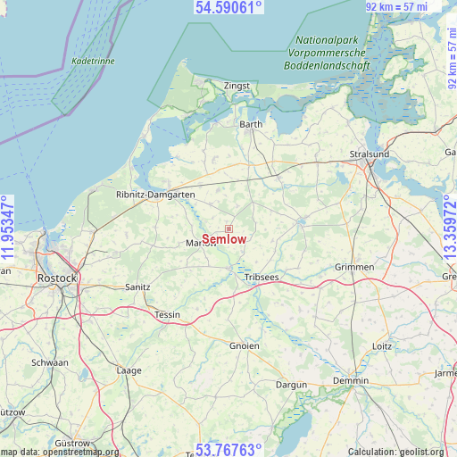
Semlow GPS coordinates[2]
54° 10' 52.212" North, 12° 39' 23.724" East
| Map corner | latitude | longitude |
|---|---|---|
| Upper-left | 54.59061°, | 11.95347° |
| Center: | 54.18117°, | 12.65659° |
| Lower-right: | 53.76763°, | 13.35972° |
| Map W x H: | 91.5×91.5 km | = 56.9×56.9mi |
| max Lat: | 55.01917° ⇑5.1% North |
| Semlow: | 54.18117° |
| min Lat: | ⇓94.9% South 47.40724° |
| min Long | Semlow | max Long |
| 5.92978° | 12.65659° | 14.98853° |
| W 89.4%⇐ | ⇒10.6% E |
Elevation
Elevation of Semlow is 28 m = 92 ft, and this is 221.1 m = 725 ft below average elevation for this country.
| Max E: |
1256 m = 4121 ft | 87.7% |
| Avg. | 249.1 m = 817 ft | |
| Semlow | 28 m = 92 ft | |
Min E: |
-5 m = -16 ft | 12.3% |
See also: Germany elevation on elevation.city.
Geographical zone
Semlow is located in North temperate zone (between Tropic of Cancer and the Arctic Circle). Distance of this North polar circle is 1376.8 km =855.5 mi to North.| Distance of | km | miles | from Semlow |
|---|---|---|---|
| North Pole | 3982.7 | 2474.7 | to North |
| Arctic Circle | 1376.8 | 855.5 | to North |
| Tropic Cancer | 3418.5 | 2124.2 | to South |
| Equator | 6024.4 | 3743.4 | to South |


Nearby cities:
15 places around Semlow: (largest is in red/bold)
• Bad Sülze
7.8 km =4.8 mi,  178°
178°
• Behren-Lübchin
16.9 km =10.5 mi, 178°
• Deyelsdorf
18.6 km =11.6 mi,  144°
144°
• Eixen
4.9 km =3 mi,  116°
116°
• Franzburg
14.7 km =9.1 mi,  88°
88°
• Jakobsdorf
18.8 km =11.7 mi,  72°
72°
• Löbnitz
13.3 km =8.3 mi,  17°
17°
• Marlow
6.2 km =3.9 mi,  241°
241°
• Ribnitz-Damgarten
14.7 km =9.1 mi,  297°
297°
• Richtenberg
15.6 km =9.7 mi,  81°
81°
• Saal
17.6 km =10.9 mi,  324°
324°
• Thelkow
17.3 km =10.7 mi,  201°
201°
• Tribsees
11.5 km =7.1 mi,  145°
145°
• Trinwillershagen
8 km =5 mi,  344°
344°
• Velgast
14.2 km =8.8 mi,  44°
44°
Sources, notices
• [Note1] Compared only with cities in Germany existing in our database
• [Src1] Map data: © OpenStreetMap contributors (CC-BY-SA)
• [Src2] Other city data from geonames.org with taken over terms of usage.
• [Src3] Geographical zone / Annual Mean Temperature by Robert A. Rohde @ Wikipedia
