Löbnitz geodata
Löbnitz (Mecklenburg-Vorpommern) is a populated place; located in Germany in Europe/Berlin (GMT+2) time zone. With population of 725 people, there are 8216 cities with bigger population in this country. Compared to other cities in Germany, 96.2% of cities are located further ↓South; 90% of cities are located further ←West and 96.2% of cities have higher elevation than Löbnitz. Note1
Administrative division(s):
- Level 1: Mecklenburg-Vorpommern
- Level 3: Vorpommern-Rügen
- Level 4: Löbnitz


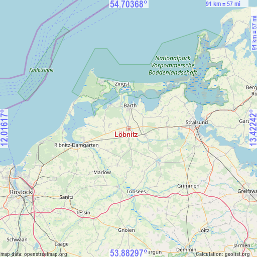
Löbnitz GPS coordinates[2]
54° 17' 43.332" North, 12° 43' 9.444" East
| Map corner | latitude | longitude |
|---|---|---|
| Upper-left | 54.70368°, | 12.01617° |
| Center: | 54.29537°, | 12.71929° |
| Lower-right: | 53.88297°, | 13.42242° |
| Map W x H: | 91.3×91.3 km | = 56.7×56.7mi |
| max Lat: | 55.01917° ⇑3.8% North |
| Löbnitz: | 54.29537° |
| min Lat: | ⇓96.2% South 47.40724° |
| min Long | Löbnitz | max Long |
| 5.92978° | 12.71929° | 14.98853° |
| W 90%⇐ | ⇒10% E |
Elevation
Elevation of Löbnitz is 6 m = 20 ft, and this is 243.1 m = 798 ft below average elevation for this country.
| Max E: |
1256 m = 4121 ft | 96.2% |
| Avg. | 249.1 m = 817 ft | |
| Löbnitz | 6 m = 20 ft | |
Min E: |
-5 m = -16 ft | 3.8% |
See also: Germany elevation on elevation.city.
Geographical zone
Löbnitz is located in North temperate zone (between Tropic of Cancer and the Arctic Circle). Distance of this North polar circle is 1364.1 km =847.6 mi to North.| Distance of | km | miles | from Löbnitz |
|---|---|---|---|
| North Pole | 3970 | 2466.8 | to North |
| Arctic Circle | 1364.1 | 847.6 | to North |
| Tropic Cancer | 3431.2 | 2132 | to South |
| Equator | 6037.1 | 3751.3 | to South |


Nearby cities:
15 places around Löbnitz: (largest is in red/bold)
• Barth
7.6 km =4.7 mi,  2°
2°
• Born
15.8 km =9.8 mi,  309°
309°
• Eixen
14.9 km =9.3 mi,  178°
178°
• Fuhlendorf
10.5 km =6.5 mi, 313°
• Jakobsdorf
15.4 km =9.6 mi,  116°
116°
• Niepars
13.5 km =8.4 mi,  80°
80°
• Pantelitz
16.2 km =10.1 mi,  87°
87°
• Pruchten
9.7 km =6 mi,  342°
342°
• Richtenberg
15.4 km =9.6 mi,  132°
132°
• Saal
14.4 km =8.9 mi,  276°
276°
• Semlow
13.3 km =8.3 mi,  197°
197°
• Trinwillershagen
8 km =5 mi,  231°
231°
• Velgast
6.5 km =4 mi,  113°
113°
• Wieck
15.5 km =9.6 mi,  324°
324°
• Zingst
15.7 km =9.8 mi,  352°
352°
Sources, notices
• [Note1] Compared only with cities in Germany existing in our database
• [Src1] Map data: © OpenStreetMap contributors (CC-BY-SA)
• [Src2] Other city data from geonames.org with taken over terms of usage.
• [Src3] Geographical zone / Annual Mean Temperature by Robert A. Rohde @ Wikipedia
