Seifhennersdorf geodata
Seifhennersdorf (Saxony) is a populated place; located in Germany in Europe/Berlin (GMT+2) time zone. With population of 4,878 people, there are 2867 cities with bigger population in this country. Compared to other cities in Germany, 56.9% of cities are located further ↓South; 99.5% of cities are located further ←West and 69.4% of cities have lower elevation than Seifhennersdorf. Note1


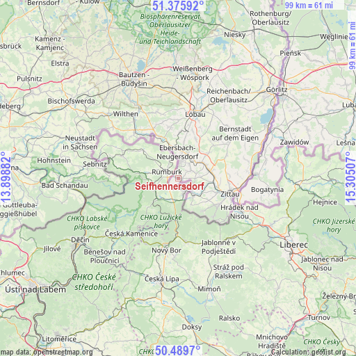
Seifhennersdorf GPS coordinates[2]
50° 56' 5.712" North, 14° 36' 6.984" East
| Map corner | latitude | longitude |
|---|---|---|
| Upper-left | 51.37592°, | 13.89882° |
| Center: | 50.93492°, | 14.60194° |
| Lower-right: | 50.4897°, | 15.30507° |
| Map W x H: | 98.5×98.5 km | = 61.2×61.2mi |
| max Lat: | 55.01917° ⇑43.1% North |
| Seifhennersdorf: | 50.93492° |
| min Lat: | ⇓56.9% South 47.40724° |
| min Long | Seifhennersdorf | max Long |
| 5.92978° | 14.60194° | 14.98853° |
| W 99.5%⇐ | ⇒0.5% E |
Elevation
Elevation of Seifhennersdorf is 354 m = 1161 ft, and this is 104.9 m = 344 ft above average elevation for this country.
| Max E: |
1256 m = 4121 ft | 30.6% |
| Seifhennersdorf | 354 m 1161 ft | |
| Avg. | 249.1 m = 817 ft | |
Min E: |
-5 m = -16 ft | 69.4% |
See also: Germany elevation on elevation.city.
Geographical zone
Seifhennersdorf is located in North temperate zone (between Tropic of Cancer and the Arctic Circle). Distance of this North polar circle is 1737.7 km =1079.8 mi to North.| Distance of | km | miles | from Seifhennersdorf |
|---|---|---|---|
| North Pole | 4343.6 | 2699 | to North |
| Arctic Circle | 1737.7 | 1079.8 | to North |
| Tropic Cancer | 3057.5 | 1899.8 | to South |
| Equator | 5663.4 | 3519.1 | to South |


Nearby cities:
15 places around Seifhennersdorf: (largest is in red/bold)
• Bertsdorf-Hörnitz
10.9 km =6.8 mi,  119°
119°
• Dürrhennersdorf
12.6 km =7.8 mi,  0°
0°
• Ebersbach
8.2 km =5.1 mi,  352°
352°
• Eibau
6.8 km =4.2 mi,  38°
38°
• Friedersdorf
10.3 km =6.4 mi,  344°
344°
• Großschönau
6.9 km =4.3 mi, 124°
• Hainewalde
7.7 km =4.8 mi,  111°
111°
• Herrnhut
13.4 km =8.3 mi,  47°
47°
• Kurort Jonsdorf
11.4 km =7.1 mi,  138°
138°
• Leutersdorf
3.8 km =2.4 mi,  63°
63°
• Mittelherwigsdorf
11.7 km =7.3 mi,  99°
99°
• Neugersdorf
4.7 km =2.9 mi,  5°
5°
• Neusalza-Spremberg
12.5 km =7.8 mi, 338°
• Olbersdorf
13.7 km =8.5 mi, 120°
• Strahwalde
13.5 km =8.4 mi, 39°
Sources, notices
• [Note1] Compared only with cities in Germany existing in our database
• [Src1] Map data: © OpenStreetMap contributors (CC-BY-SA)
• [Src2] Other city data from geonames.org with taken over terms of usage.
• [Src3] Geographical zone / Annual Mean Temperature by Robert A. Rohde @ Wikipedia
