Dürrhennersdorf geodata
Dürrhennersdorf (Saxony) is a seat of a fourth-order administrative division; located in Germany in Europe/Berlin (GMT+2) time zone. With population of 1,213 people, there are 6527 cities with bigger population in this country. Compared to other cities in Germany, 58.9% of cities are located further ↓South; 99.5% of cities are located further ←West and 68.4% of cities have lower elevation than Dürrhennersdorf. Note1


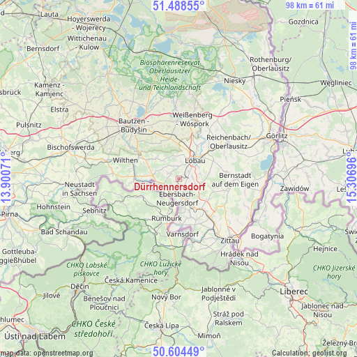
Dürrhennersdorf GPS coordinates[2]
51° 2' 55.068" North, 14° 36' 13.788" East
| Map corner | latitude | longitude |
|---|---|---|
| Upper-left | 51.48855°, | 13.90071° |
| Center: | 51.04863°, | 14.60383° |
| Lower-right: | 50.60449°, | 15.30696° |
| Map W x H: | 98.3×98.3 km | = 61.1×61.1mi |
| max Lat: | 55.01917° ⇑41.1% North |
| Dürrhennersdorf: | 51.04863° |
| min Lat: | ⇓58.9% South 47.40724° |
| min Long | Dürrhennersdor | max Long |
| 5.92978° | 14.60383° | 14.98853° |
| W 99.5%⇐ | ⇒0.5% E |
Elevation
Elevation of Dürrhennersdorf is 346 m = 1135 ft, and this is 96.9 m = 318 ft above average elevation for this country.
| Max E: |
1256 m = 4121 ft | 31.6% |
| Dürrhennersdorf | 346 m 1135 ft | |
| Avg. | 249.1 m = 817 ft | |
Min E: |
-5 m = -16 ft | 68.4% |
See also: Germany elevation on elevation.city.
Geographical zone
Dürrhennersdorf is located in North temperate zone (between Tropic of Cancer and the Arctic Circle). Distance of this North polar circle is 1725.1 km =1071.9 mi to North.| Distance of | km | miles | from Dürrhennersdorf |
|---|---|---|---|
| North Pole | 4331 | 2691.2 | to North |
| Arctic Circle | 1725.1 | 1071.9 | to North |
| Tropic Cancer | 3070.2 | 1907.7 | to South |
| Equator | 5676.1 | 3527 | to South |


Nearby cities:
15 places around Dürrhennersdorf: (largest is in red/bold)
• Beiersdorf
5.4 km =3.4 mi,  301°
301°
• Cunewalde
8.3 km =5.2 mi,  313°
313°
• Ebersbach
4.7 km =2.9 mi,  195°
195°
• Eibau
8.4 km =5.2 mi,  150°
150°
• Friedersdorf
4 km =2.5 mi,  226°
226°
• Großschweidnitz
3.6 km =2.2 mi,  49°
49°
• Herrnhut
10.4 km =6.5 mi,  110°
110°
• Lawalde
3.9 km =2.4 mi,  356°
356°
• Löbau
7.2 km =4.5 mi,  38°
38°
• Neugersdorf
7.9 km =4.9 mi,  177°
177°
• Neusalza-Spremberg
4.9 km =3 mi,  257°
257°
• Niedercunnersdorf
3.9 km =2.4 mi,  81°
81°
• Oppach
7.5 km =4.7 mi,  285°
285°
• Schönbach
3.3 km =2.1 mi, 307°
• Strahwalde
8.7 km =5.4 mi,  104°
104°
Sources, notices
• [Note1] Compared only with cities in Germany existing in our database
• [Src1] Map data: © OpenStreetMap contributors (CC-BY-SA)
• [Src2] Other city data from geonames.org with taken over terms of usage.
• [Src3] Geographical zone / Annual Mean Temperature by Robert A. Rohde @ Wikipedia
