Eibau geodata
Eibau (Saxony) is a populated place; located in Germany in Europe/Berlin (GMT+2) time zone. With population of 5,103 people, there are 2789 cities with bigger population in this country. Compared to other cities in Germany, 57.8% of cities are located further ↓South; 99.7% of cities are located further ←West and 70% of cities have lower elevation than Eibau. Note1


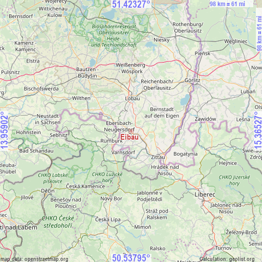
Eibau GPS coordinates[2]
50° 58' 57.792" North, 14° 39' 43.704" East
| Map corner | latitude | longitude |
|---|---|---|
| Upper-left | 51.42327°, | 13.95902° |
| Center: | 50.98272°, | 14.66214° |
| Lower-right: | 50.53795°, | 15.36527° |
| Map W x H: | 98.4×98.4 km | = 61.1×61.1mi |
| max Lat: | 55.01917° ⇑42.2% North |
| Eibau: | 50.98272° |
| min Lat: | ⇓57.8% South 47.40724° |
| min Long | Eibau | max Long |
| 5.92978° | 14.66214° | 14.98853° |
| W 99.7%⇐ | ⇒0.3% E |
Elevation
Elevation of Eibau is 358 m = 1175 ft, and this is 108.9 m = 357 ft above average elevation for this country.
| Max E: |
1256 m = 4121 ft | 30% |
| Eibau | 358 m 1175 ft | |
| Avg. | 249.1 m = 817 ft | |
Min E: |
-5 m = -16 ft | 70% |
See also: Germany elevation on elevation.city.
Geographical zone
Eibau is located in North temperate zone (between Tropic of Cancer and the Arctic Circle). Distance of this North polar circle is 1732.4 km =1076.5 mi to North.| Distance of | km | miles | from Eibau |
|---|---|---|---|
| North Pole | 4338.3 | 2695.7 | to North |
| Arctic Circle | 1732.4 | 1076.5 | to North |
| Tropic Cancer | 3062.8 | 1903.1 | to South |
| Equator | 5668.7 | 3522.4 | to South |


Nearby cities:
15 places around Eibau: (largest is in red/bold)
• Dürrhennersdorf
8.4 km =5.2 mi,  330°
330°
• Ebersbach
6 km =3.7 mi,  297°
297°
• Friedersdorf
8.4 km =5.2 mi, 303°
• Großhennersdorf
8.8 km =5.5 mi,  87°
87°
• Großschweidnitz
9.7 km =6 mi,  352°
352°
• Großschönau
9.3 km =5.8 mi,  170°
170°
• Hainewalde
8.6 km =5.3 mi,  160°
160°
• Herrnhut
6.8 km =4.2 mi,  56°
56°
• Leutersdorf
3.7 km =2.3 mi,  193°
193°
• Mittelherwigsdorf
10.4 km =6.5 mi,  135°
135°
• Neugersdorf
3.8 km =2.4 mi,  260°
260°
• Neusalza-Spremberg
10.9 km =6.8 mi,  305°
305°
• Niedercunnersdorf
7.9 km =4.9 mi,  358°
358°
• Seifhennersdorf
6.8 km =4.2 mi,  218°
218°
• Strahwalde
6.7 km =4.2 mi,  40°
40°
Sources, notices
• [Note1] Compared only with cities in Germany existing in our database
• [Src1] Map data: © OpenStreetMap contributors (CC-BY-SA)
• [Src2] Other city data from geonames.org with taken over terms of usage.
• [Src3] Geographical zone / Annual Mean Temperature by Robert A. Rohde @ Wikipedia
