Schwifting geodata
Schwifting (Bavaria) is a seat of a fourth-order administrative division; located in Germany in Europe/Berlin (GMT+2) time zone. With population of 871 people, there are 7623 cities with bigger population in this country. Compared to other cities in Germany, 94.9% of cities are located further ↑North; 65.9% of cities are located further ←West and 96.3% of cities have lower elevation than Schwifting. Note1
Administrative division(s):
- Level 1: Bavaria
- Level 2: Upper Bavaria
- Level 3: Landkreis Landsberg am Lech
- Level 4: Schwifting


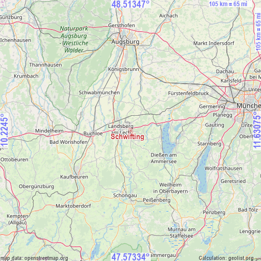
Schwifting GPS coordinates[2]
48° 2' 43.98" North, 10° 55' 39.432" East
| Map corner | latitude | longitude |
|---|---|---|
| Upper-left | 48.51347°, | 10.2245° |
| Center: | 48.04555°, | 10.92762° |
| Lower-right: | 47.57334°, | 11.63075° |
| Map W x H: | 104.5×104.5 km | = 64.9×64.9mi |
| max Lat: | 55.01917° ⇑94.9% North |
| Schwifting: | 48.04555° |
| min Lat: | ⇓5.1% South 47.40724° |
| min Long | Schwifting | max Long |
| 5.92978° | 10.92762° | 14.98853° |
| W 65.9%⇐ | ⇒34.1% E |
Elevation
Elevation of Schwifting is 636 m = 2087 ft, and this is 386.9 m = 1269 ft above average elevation for this country.
| Max E: |
1256 m = 4121 ft | 3.7% |
| Schwifting | 636 m 2087 ft | |
| Avg. | 249.1 m = 817 ft | |
Min E: |
-5 m = -16 ft | 96.3% |
See also: Germany elevation on elevation.city.
Geographical zone
Schwifting is located in North temperate zone (between Tropic of Cancer and the Arctic Circle). Distance of this North polar circle is 2059 km =1279.4 mi to North.| Distance of | km | miles | from Schwifting |
|---|---|---|---|
| North Pole | 4664.9 | 2898.6 | to North |
| Arctic Circle | 2059 | 1279.4 | to North |
| Tropic Cancer | 2736.2 | 1700.2 | to South |
| Equator | 5342.2 | 3319.5 | to South |


Nearby cities:
15 places around Schwifting: (largest is in red/bold)
• Eresing
8.5 km =5.3 mi,  57°
57°
• Geltendorf
11.1 km =6.9 mi,  44°
44°
• Greifenberg
11.9 km =7.4 mi,  76°
76°
• Hofstetten
5.2 km =3.2 mi,  141°
141°
• Hurlach
11.9 km =7.4 mi,  313°
313°
• Kaufering
6.2 km =3.9 mi,  324°
324°
• Landsberg am Lech
3.3 km =2.1 mi,  275°
275°
• Penzing
3.3 km =2.1 mi,  359°
359°
• Pürgen
2.4 km =1.5 mi,  189°
189°
• Thaining
8.4 km =5.2 mi,  164°
164°
• Unterdießen
9.9 km =6.2 mi,  225°
225°
• Utting am Ammersee
12 km =7.5 mi,  100°
100°
• Vilgertshofen
10.7 km =6.6 mi,  184°
184°
• Weil
8 km =5 mi, 356°
• Windach
8.2 km =5.1 mi,  73°
73°
Sources, notices
• [Note1] Compared only with cities in Germany existing in our database
• [Src1] Map data: © OpenStreetMap contributors (CC-BY-SA)
• [Src2] Other city data from geonames.org with taken over terms of usage.
• [Src3] Geographical zone / Annual Mean Temperature by Robert A. Rohde @ Wikipedia
