Unterdießen geodata
Unterdießen (Bavaria) is a seat of a fourth-order administrative division; located in Germany in Europe/Berlin (GMT+2) time zone. With population of 1,323 people, there are 6240 cities with bigger population in this country. Compared to other cities in Germany, 95.7% of cities are located further ↑North; 64.5% of cities are located further ←West and 96.2% of cities have lower elevation than Unterdießen. Note1
Administrative division(s):
- Level 1: Bavaria
- Level 2: Upper Bavaria
- Level 3: Landkreis Landsberg am Lech
- Level 4: Unterdießen


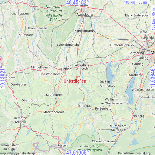
Unterdießen GPS coordinates[2]
47° 58' 59.988" North, 10° 49' 59.988" East
| Map corner | latitude | longitude |
|---|---|---|
| Upper-left | 48.45182°, | 10.13021° |
| Center: | 47.98333°, | 10.83333° |
| Lower-right: | 47.51055°, | 11.53646° |
| Map W x H: | 104.7×104.7 km | = 65.1×65.1mi |
| max Lat: | 55.01917° ⇑95.7% North |
| Unterdießen: | 47.98333° |
| min Lat: | ⇓4.3% South 47.40724° |
| min Long | Unterdießen | max Long |
| 5.92978° | 10.83333° | 14.98853° |
| W 64.5%⇐ | ⇒35.5% E |
Elevation
Elevation of Unterdießen is 635 m = 2083 ft, and this is 385.9 m = 1266 ft above average elevation for this country.
| Max E: |
1256 m = 4121 ft | 3.8% |
| Unterdießen | 635 m 2083 ft | |
| Avg. | 249.1 m = 817 ft | |
Min E: |
-5 m = -16 ft | 96.2% |
See also: Germany elevation on elevation.city.
Geographical zone
Unterdießen is located in North temperate zone (between Tropic of Cancer and the Arctic Circle). Distance of this North polar circle is 2065.9 km =1283.7 mi to North.| Distance of | km | miles | from Unterdießen |
|---|---|---|---|
| North Pole | 4671.8 | 2902.9 | to North |
| Arctic Circle | 2065.9 | 1283.7 | to North |
| Tropic Cancer | 2729.3 | 1695.9 | to South |
| Equator | 5335.2 | 3315.1 | to South |


Nearby cities:
15 places around Unterdießen: (largest is in red/bold)
• Apfeldorf
11.9 km =7.4 mi,  141°
141°
• Buchloe
10 km =6.2 mi,  306°
306°
• Denklingen
7.5 km =4.7 mi,  170°
170°
• Hofstetten
10.6 km =6.6 mi,  74°
74°
• Jengen
8.2 km =5.1 mi,  282°
282°
• Landsberg am Lech
8.1 km =5 mi,  27°
27°
• Oberostendorf
8.1 km =5 mi,  236°
236°
• Penzing
12.3 km =7.6 mi, 34°
• Pürgen
8.1 km =5 mi,  55°
55°
• Reichling
9.8 km =6.1 mi,  133°
133°
• Schwifting
9.9 km =6.2 mi,  45°
45°
• Thaining
9.3 km =5.8 mi,  97°
97°
• Vilgertshofen
7.2 km =4.5 mi,  120°
120°
• Waal
4.4 km =2.7 mi,  289°
289°
• Westendorf
10.3 km =6.4 mi, 237°
Sources, notices
• [Note1] Compared only with cities in Germany existing in our database
• [Src1] Map data: © OpenStreetMap contributors (CC-BY-SA)
• [Src2] Other city data from geonames.org with taken over terms of usage.
• [Src3] Geographical zone / Annual Mean Temperature by Robert A. Rohde @ Wikipedia
