Pürgen geodata
Pürgen (Bavaria) is a seat of a fourth-order administrative division; located in Germany in Europe/Berlin (GMT+2) time zone. With population of 3,186 people, there are 3838 cities with bigger population in this country. Compared to other cities in Germany, 95.2% of cities are located further ↑North; 65.8% of cities are located further ←West and 96.6% of cities have lower elevation than Pürgen. Note1
Administrative division(s):
- Level 1: Bavaria
- Level 2: Upper Bavaria
- Level 3: Landkreis Landsberg am Lech
- Level 4: Pürgen


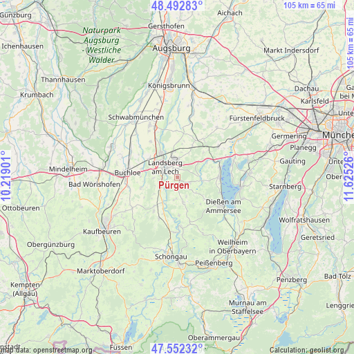
Pürgen GPS coordinates[2]
48° 1' 28.992" North, 10° 55' 19.668" East
| Map corner | latitude | longitude |
|---|---|---|
| Upper-left | 48.49283°, | 10.21901° |
| Center: | 48.02472°, | 10.92213° |
| Lower-right: | 47.55232°, | 11.62526° |
| Map W x H: | 104.6×104.6 km | = 65×65mi |
| max Lat: | 55.01917° ⇑95.2% North |
| Pürgen: | 48.02472° |
| min Lat: | ⇓4.8% South 47.40724° |
| min Long | Pürgen | max Long |
| 5.92978° | 10.92213° | 14.98853° |
| W 65.8%⇐ | ⇒34.2% E |
Elevation
Elevation of Pürgen is 646 m = 2119 ft, and this is 396.9 m = 1302 ft above average elevation for this country.
| Max E: |
1256 m = 4121 ft | 3.4% |
| Pürgen | 646 m 2119 ft | |
| Avg. | 249.1 m = 817 ft | |
Min E: |
-5 m = -16 ft | 96.6% |
See also: Germany elevation on elevation.city.
Geographical zone
Pürgen is located in North temperate zone (between Tropic of Cancer and the Arctic Circle). Distance of this North polar circle is 2061.3 km =1280.8 mi to North.| Distance of | km | miles | from Pürgen |
|---|---|---|---|
| North Pole | 4667.2 | 2900.1 | to North |
| Arctic Circle | 2061.3 | 1280.8 | to North |
| Tropic Cancer | 2733.9 | 1698.8 | to South |
| Equator | 5339.8 | 3318 | to South |


Nearby cities:
15 places around Pürgen: (largest is in red/bold)
• Eresing
10.3 km =6.4 mi,  47°
47°
• Greifenberg
13 km =8.1 mi,  66°
66°
• Hofstetten
4.1 km =2.5 mi,  116°
116°
• Kaufering
8.1 km =5 mi,  336°
336°
• Landsberg am Lech
3.9 km =2.4 mi,  311°
311°
• Penzing
5.6 km =3.5 mi,  4°
4°
• Reichling
11.3 km =7 mi,  177°
177°
• Schwifting
2.4 km =1.5 mi,  9°
9°
• Thaining
6.3 km =3.9 mi,  155°
155°
• Unterdießen
8.1 km =5 mi,  235°
235°
• Utting am Ammersee
12.2 km =7.6 mi,  89°
89°
• Vilgertshofen
8.3 km =5.2 mi, 182°
• Waal
11.2 km =7 mi,  253°
253°
• Weil
10.3 km =6.4 mi,  359°
359°
• Windach
9.5 km =5.9 mi,  60°
60°
Sources, notices
• [Note1] Compared only with cities in Germany existing in our database
• [Src1] Map data: © OpenStreetMap contributors (CC-BY-SA)
• [Src2] Other city data from geonames.org with taken over terms of usage.
• [Src3] Geographical zone / Annual Mean Temperature by Robert A. Rohde @ Wikipedia
