Fretterode geodata
Fretterode (Thuringia) is a seat of a fourth-order administrative division; located in Germany in Europe/Berlin (GMT+2) time zone. With population of 190 people, there are 10516 cities with bigger population in this country. Compared to other cities in Germany, 63.5% of cities are located further ↓South; 50% of cities are located further ←West and 66.2% of cities have lower elevation than Fretterode. Note1


Fretterode GPS coordinates[2]
51° 19' 0.012" North, 10° 0' 0" East
| Map corner | latitude | longitude |
|---|---|---|
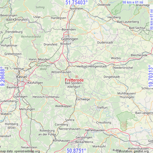
| Upper-left | 51.75403°, | 9.29688° |
| Center: | 51.31667°, | 10° |
| Lower-right: | 50.8751°, | 10.70313° |
| Map W x H: | 97.7×97.7 km | = 60.7×60.7mi |
| max Lat: | 55.01917° ⇑36.5% North |
| Fretterode: | 51.31667° |
| min Lat: | ⇓63.5% South 47.40724° |
| min Long | Fretterode | max Long |
| 5.92978° | 10° | 14.98853° |
| W 50%⇐ | ⇒50% E |
Elevation
Elevation of Fretterode is 330 m = 1083 ft, and this is 80.9 m = 265 ft above average elevation for this country.
| Max E: |
1256 m = 4121 ft | 33.8% |
| Fretterode | 330 m 1083 ft | |
| Avg. | 249.1 m = 817 ft | |
Min E: |
-5 m = -16 ft | 66.2% |
See also: Germany elevation on elevation.city.
Geographical zone
Fretterode is located in North temperate zone (between Tropic of Cancer and the Arctic Circle). Distance of this North polar circle is 1695.3 km =1053.4 mi to North.| Distance of | km | miles | from Fretterode |
|---|---|---|---|
| North Pole | 4301.2 | 2672.6 | to North |
| Arctic Circle | 1695.3 | 1053.4 | to North |
| Tropic Cancer | 3100 | 1926.3 | to South |
| Equator | 5705.9 | 3545.5 | to South |


Nearby cities:
15 places around Fretterode: (largest is in red/bold)
• Arenshausen
7 km =4.3 mi,  341°
341°
• Bad Sooden-Allendorf
5.4 km =3.4 mi,  198°
198°
• Birkenfelde
3.9 km =2.4 mi,  17°
17°
• Bornhagen
3.9 km =2.4 mi,  298°
298°
• Eichstruth
6.1 km =3.8 mi,  107°
107°
• Gerbershausen
2.2 km =1.4 mi,  327°
327°
• Lenterode
5 km =3.1 mi,  68°
68°
• Lindewerra
3.5 km =2.2 mi,  270°
270°
• Mackenrode
5 km =3.1 mi, 111°
• Röhrig
3 km =1.9 mi,  51°
51°
• Schönhagen
2.9 km =1.8 mi,  30°
30°
• Thalwenden
5.1 km =3.2 mi,  43°
43°
• Uder
7.1 km =4.4 mi, 44°
• Wahlhausen
2.2 km =1.4 mi,  212°
212°
• Wüstheuterode
4.2 km =2.6 mi,  79°
79°
Sources, notices
• [Note1] Compared only with cities in Germany existing in our database
• [Src1] Map data: © OpenStreetMap contributors (CC-BY-SA)
• [Src2] Other city data from geonames.org with taken over terms of usage.
• [Src3] Geographical zone / Annual Mean Temperature by Robert A. Rohde @ Wikipedia
