Schöngleina geodata
Schöngleina (Thuringia) is a seat of a fourth-order administrative division; located in Germany in Europe/Berlin (GMT+2) time zone. With population of 543 people, there are 9125 cities with bigger population in this country. Compared to other cities in Germany, 56.3% of cities are located further ↓South; 77.6% of cities are located further ←West and 57.6% of cities have lower elevation than Schöngleina. Note1


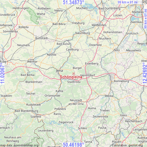
Schöngleina GPS coordinates[2]
50° 54' 26.892" North, 11° 43' 25.644" East
| Map corner | latitude | longitude |
|---|---|---|
| Upper-left | 51.34873°, | 11.02067° |
| Center: | 50.90747°, | 11.72379° |
| Lower-right: | 50.46198°, | 12.42692° |
| Map W x H: | 98.6×98.6 km | = 61.3×61.3mi |
| max Lat: | 55.01917° ⇑43.7% North |
| Schöngleina: | 50.90747° |
| min Lat: | ⇓56.3% South 47.40724° |
| min Long | Schöngleina | max Long |
| 5.92978° | 11.72379° | 14.98853° |
| W 77.6%⇐ | ⇒22.4% E |
Elevation
Elevation of Schöngleina is 276 m = 906 ft, and this is 26.9 m = 88 ft above average elevation for this country.
| Max E: |
1256 m = 4121 ft | 42.4% |
| Schöngleina | 276 m 906 ft | |
| Avg. | 249.1 m = 817 ft | |
Min E: |
-5 m = -16 ft | 57.6% |
See also: Germany elevation on elevation.city.
Geographical zone
Schöngleina is located in North temperate zone (between Tropic of Cancer and the Arctic Circle). Distance of this North polar circle is 1740.8 km =1081.7 mi to North.| Distance of | km | miles | from Schöngleina |
|---|---|---|---|
| North Pole | 4346.7 | 2700.9 | to North |
| Arctic Circle | 1740.8 | 1081.7 | to North |
| Tropic Cancer | 3054.5 | 1898 | to South |
| Equator | 5660.4 | 3517.2 | to South |


Nearby cities:
15 places around Schöngleina: (largest is in red/bold)
• Albersdorf
3.5 km =2.2 mi,  97°
97°
• Bobeck
4.9 km =3 mi, 95°
• Bollberg
6 km =3.7 mi,  116°
116°
• Bürgel
4.5 km =2.8 mi,  30°
30°
• Großlöbichau
3.8 km =2.4 mi,  306°
306°
• Jenalöbnitz
5 km =3.1 mi,  340°
340°
• Laasdorf
5.4 km =3.4 mi,  221°
221°
• Nausnitz
4.8 km =3 mi,  8°
8°
• Quirla
5.4 km =3.4 mi,  146°
146°
• Rausdorf
5.4 km =3.4 mi,  212°
212°
• Ruttersdorf-Lotschen
2.8 km =1.7 mi,  166°
166°
• Scheiditz
2.2 km =1.4 mi, 96°
• Schlöben
2.9 km =1.8 mi,  238°
238°
• Stadtroda
5.6 km =3.5 mi,  177°
177°
• Waldeck
4.3 km =2.7 mi,  76°
76°
Sources, notices
• [Note1] Compared only with cities in Germany existing in our database
• [Src1] Map data: © OpenStreetMap contributors (CC-BY-SA)
• [Src2] Other city data from geonames.org with taken over terms of usage.
• [Src3] Geographical zone / Annual Mean Temperature by Robert A. Rohde @ Wikipedia
