Schöneberg geodata
Schöneberg (Berlin) is a section of populated place; located in Germany in Europe/Berlin (GMT+2) time zone. With population of 115,976 people, there are 83 cities with bigger population in this country. Compared to other cities in Germany, 77% of cities are located further ↓South; 94.7% of cities are located further ←West and 79.9% of cities have higher elevation than Schöneberg. Note1


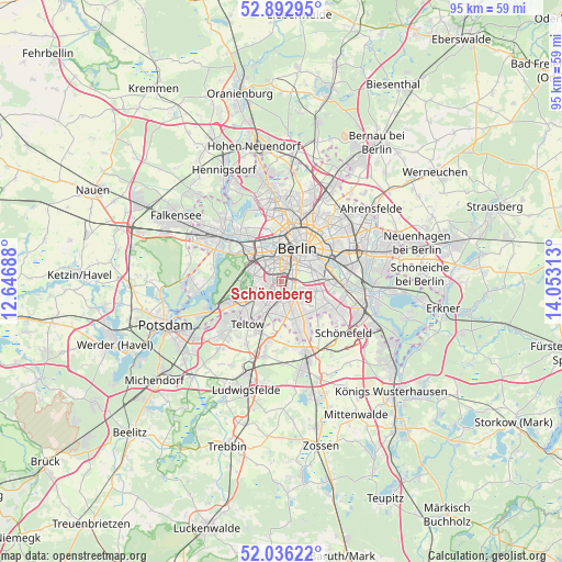
Schöneberg GPS coordinates[2]
52° 28' 0.012" North, 13° 21' 0" East
| Map corner | latitude | longitude |
|---|---|---|
| Upper-left | 52.89295°, | 12.64688° |
| Center: | 52.46667°, | 13.35° |
| Lower-right: | 52.03622°, | 14.05313° |
| Map W x H: | 95.3×95.3 km | = 59.2×59.2mi |
| max Lat: | 55.01917° ⇑23% North |
| Schöneberg: | 52.46667° |
| min Lat: | ⇓77% South 47.40724° |
| min Long | Schöneberg | max Long |
| 5.92978° | 13.35° | 14.98853° |
| W 94.7%⇐ | ⇒5.3% E |
Elevation
Elevation of Schöneberg is 47 m = 154 ft, and this is 202.1 m = 663 ft below average elevation for this country.
| Max E: |
1256 m = 4121 ft | 79.9% |
| Avg. | 249.1 m = 817 ft | |
| Schöneberg | 47 m = 154 ft | |
Min E: |
-5 m = -16 ft | 20.1% |
See also: Schöneberg elevation on elevation.city.
Geographical zone
Schöneberg is located in North temperate zone (between Tropic of Cancer and the Arctic Circle). Distance of this North polar circle is 1567.4 km =973.9 mi to North.| Distance of | km | miles | from Schöneberg |
|---|---|---|---|
| North Pole | 4173.3 | 2593.2 | to North |
| Arctic Circle | 1567.4 | 973.9 | to North |
| Tropic Cancer | 3227.8 | 2005.7 | to South |
| Equator | 5833.7 | 3624.9 | to South |


Nearby cities:
15 places around Schöneberg: (largest is in red/bold)
• Dahlem
4.4 km =2.7 mi,  257°
257°
• Friedenau
1.6 km =1 mi,  289°
289°
• Halensee
4.5 km =2.8 mi,  305°
305°
• Hansaviertel
5.8 km =3.6 mi,  354°
354°
• Kreuzberg
5.2 km =3.2 mi,  44°
44°
• Lankwitz
3.4 km =2.1 mi,  184°
184°
• Lichterfelde
4.7 km =2.9 mi,  217°
217°
• Mariendorf
3.8 km =2.4 mi,  146°
146°
• Marienfelde
5.5 km =3.4 mi,  167°
167°
• Neukölln
5.6 km =3.5 mi,  78°
78°
• Schmargendorf
4.1 km =2.5 mi,  283°
283°
• Steglitz
1.7 km =1.1 mi,  225°
225°
• Tempelhof
3.4 km =2.1 mi,  90°
90°
• Tiergarten
5.7 km =3.5 mi,  11°
11°
• Wilmersdorf
2.9 km =1.8 mi, 309°
Sources, notices
• [Note1] Compared only with cities in Germany existing in our database
• [Src1] Map data: © OpenStreetMap contributors (CC-BY-SA)
• [Src2] Other city data from geonames.org with taken over terms of usage.
• [Src3] Geographical zone / Annual Mean Temperature by Robert A. Rohde @ Wikipedia
