Friedenau geodata
Friedenau (Berlin) is a section of populated place; located in Germany in Europe/Berlin (GMT+2) time zone. With population of 26,972 people, there are 536 cities with bigger population in this country. Compared to other cities in Germany, 77.1% of cities are located further ↓South; 94.5% of cities are located further ←West and 81% of cities have higher elevation than Friedenau. Note1


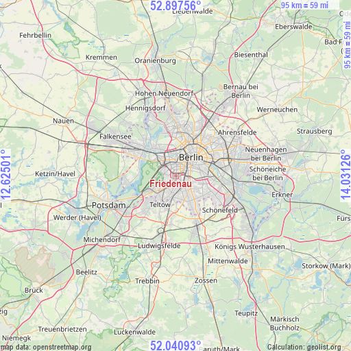
Friedenau GPS coordinates[2]
52° 28' 16.788" North, 13° 19' 41.268" East
| Map corner | latitude | longitude |
|---|---|---|
| Upper-left | 52.89756°, | 12.62501° |
| Center: | 52.47133°, | 13.32813° |
| Lower-right: | 52.04093°, | 14.03126° |
| Map W x H: | 95.2×95.2 km | = 59.2×59.2mi |
| max Lat: | 55.01917° ⇑22.9% North |
| Friedenau: | 52.47133° |
| min Lat: | ⇓77.1% South 47.40724° |
| min Long | Friedenau | max Long |
| 5.92978° | 13.32813° | 14.98853° |
| W 94.5%⇐ | ⇒5.5% E |
Elevation
Elevation of Friedenau is 44 m = 144 ft, and this is 205.1 m = 673 ft below average elevation for this country.
| Max E: |
1256 m = 4121 ft | 81% |
| Avg. | 249.1 m = 817 ft | |
| Friedenau | 44 m = 144 ft | |
Min E: |
-5 m = -16 ft | 19% |
See also: Germany elevation on elevation.city.
Geographical zone
Friedenau is located in North temperate zone (between Tropic of Cancer and the Arctic Circle). Distance of this North polar circle is 1566.9 km =973.6 mi to North.| Distance of | km | miles | from Friedenau |
|---|---|---|---|
| North Pole | 4172.8 | 2592.9 | to North |
| Arctic Circle | 1566.9 | 973.6 | to North |
| Tropic Cancer | 3228.3 | 2006 | to South |
| Equator | 5834.3 | 3625.3 | to South |


Nearby cities:
15 places around Friedenau: (largest is in red/bold)
• Charlottenburg
5.9 km =3.7 mi,  328°
328°
• Dahlem
3.1 km =1.9 mi,  242°
242°
• Grunewald
4.4 km =2.7 mi,  287°
287°
• Halensee
3 km =1.9 mi,  313°
313°
• Hansaviertel
5.3 km =3.3 mi,  9°
9°
• Kreuzberg
6 km =3.7 mi,  58°
58°
• Lankwitz
4.1 km =2.5 mi,  162°
162°
• Lichterfelde
4.5 km =2.8 mi,  198°
198°
• Mariendorf
5.2 km =3.2 mi,  136°
136°
• Schmargendorf
2.6 km =1.6 mi,  279°
279°
• Schöneberg
1.6 km =1 mi,  109°
109°
• Steglitz
1.7 km =1.1 mi,  171°
171°
• Tempelhof
4.9 km =3 mi,  96°
96°
• Tiergarten
5.7 km =3.5 mi,  27°
27°
• Wilmersdorf
1.5 km =0.9 mi, 329°
Sources, notices
• [Note1] Compared only with cities in Germany existing in our database
• [Src1] Map data: © OpenStreetMap contributors (CC-BY-SA)
• [Src2] Other city data from geonames.org with taken over terms of usage.
• [Src3] Geographical zone / Annual Mean Temperature by Robert A. Rohde @ Wikipedia
