Hansaviertel geodata
Hansaviertel (Berlin) is a section of populated place; located in Germany in Europe/Berlin (GMT+2) time zone. With population of 5,629 people, there are 2581 cities with bigger population in this country. Compared to other cities in Germany, 77.7% of cities are located further ↓South; 94.6% of cities are located further ←West and 83.7% of cities have higher elevation than Hansaviertel. Note1


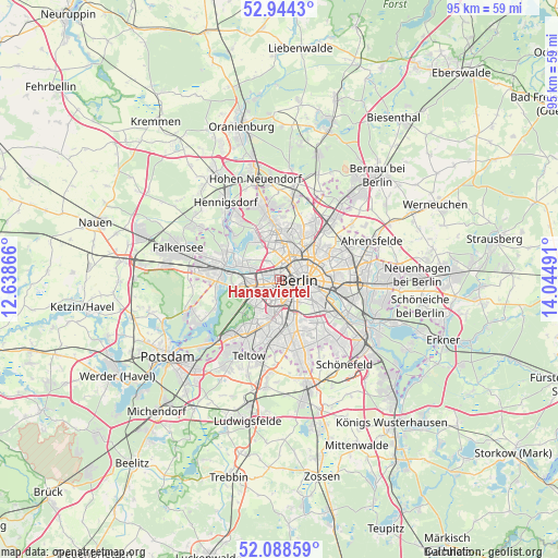
Hansaviertel GPS coordinates[2]
52° 31' 6.708" North, 13° 20' 30.408" East
| Map corner | latitude | longitude |
|---|---|---|
| Upper-left | 52.9443°, | 12.63866° |
| Center: | 52.51853°, | 13.34178° |
| Lower-right: | 52.08859°, | 14.04491° |
| Map W x H: | 95.1×95.1 km | = 59.1×59.1mi |
| max Lat: | 55.01917° ⇑22.3% North |
| Hansaviertel: | 52.51853° |
| min Lat: | ⇓77.7% South 47.40724° |
| min Long | Hansaviertel | max Long |
| 5.92978° | 13.34178° | 14.98853° |
| W 94.6%⇐ | ⇒5.4% E |
Elevation
Elevation of Hansaviertel is 38 m = 125 ft, and this is 211.1 m = 693 ft below average elevation for this country.
| Max E: |
1256 m = 4121 ft | 83.7% |
| Avg. | 249.1 m = 817 ft | |
| Hansaviertel | 38 m = 125 ft | |
Min E: |
-5 m = -16 ft | 16.3% |
See also: Germany elevation on elevation.city.
Geographical zone
Hansaviertel is located in North temperate zone (between Tropic of Cancer and the Arctic Circle). Distance of this North polar circle is 1561.7 km =970.4 mi to North.| Distance of | km | miles | from Hansaviertel |
|---|---|---|---|
| North Pole | 4167.5 | 2589.6 | to North |
| Arctic Circle | 1561.7 | 970.4 | to North |
| Tropic Cancer | 3233.6 | 2009.3 | to South |
| Equator | 5839.5 | 3628.5 | to South |


Nearby cities:
15 places around Hansaviertel: (largest is in red/bold)
• Berlin
4.7 km =2.9 mi,  82°
82°
• Charlottenburg
4 km =2.5 mi,  267°
267°
• Charlottenburg-Nord
3.5 km =2.2 mi,  292°
292°
• Friedenau
5.3 km =3.3 mi,  189°
189°
• Gesundbrunnen
4.9 km =3 mi,  43°
43°
• Halensee
4.4 km =2.7 mi,  224°
224°
• Kreuzberg
4.7 km =2.9 mi,  116°
116°
• Mitte
4.3 km =2.7 mi,  87°
87°
• Moabit
0.9 km =0.6 mi,  347°
347°
• Reinickendorf
5.4 km =3.4 mi, 353°
• Schöneberg
5.8 km =3.6 mi,  174°
174°
• Tiergarten
1.7 km =1.1 mi,  97°
97°
• Wedding
3.3 km =2.1 mi,  16°
16°
• Westend
4.4 km =2.7 mi, 267°
• Wilmersdorf
4.3 km =2.7 mi,  203°
203°
Sources, notices
• [Note1] Compared only with cities in Germany existing in our database
• [Src1] Map data: © OpenStreetMap contributors (CC-BY-SA)
• [Src2] Other city data from geonames.org with taken over terms of usage.
• [Src3] Geographical zone / Annual Mean Temperature by Robert A. Rohde @ Wikipedia
