Schöllkrippen geodata
Schöllkrippen (Bavaria) is a populated place; located in Germany in Europe/Berlin (GMT+2) time zone. With population of 3,868 people, there are 3369 cities with bigger population in this country. Compared to other cities in Germany, 61.6% of cities are located further ↑North; 61.6% of cities are located further →East and 52.3% of cities have higher elevation than Schöllkrippen. Note1
Administrative division(s):
- Level 1: Bavaria
- Level 2: Regierungsbezirk Unterfranken
- Level 3: Landkreis Aschaffenburg
- Level 4: Schöllkrippen, Markt


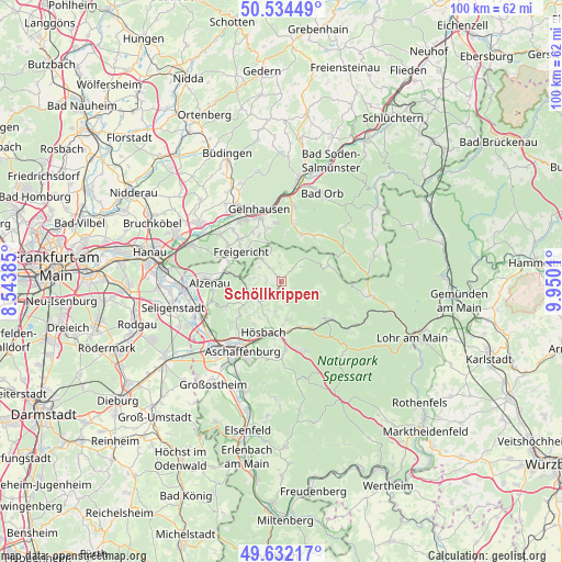
Schöllkrippen GPS coordinates[2]
50° 5' 7.62" North, 9° 14' 49.092" East
| Map corner | latitude | longitude |
|---|---|---|
| Upper-left | 50.53449°, | 8.54385° |
| Center: | 50.08545°, | 9.24697° |
| Lower-right: | 49.63217°, | 9.9501° |
| Map W x H: | 100.3×100.3 km | = 62.3×62.3mi |
| max Lat: | 55.01917° ⇑61.6% North |
| Schöllkrippen: | 50.08545° |
| min Lat: | ⇓38.4% South 47.40724° |
| min Long | Schöllkrippen | max Long |
| 5.92978° | 9.24697° | 14.98853° |
| W 38.4%⇐ | ⇒61.6% E |
Elevation
Elevation of Schöllkrippen is 209 m = 686 ft, and this is 40.1 m = 132 ft below average elevation for this country.
| Max E: |
1256 m = 4121 ft | 52.3% |
| Avg. | 249.1 m = 817 ft | |
| Schöllkrippen | 209 m = 686 ft | |
Min E: |
-5 m = -16 ft | 47.7% |
See also: Germany elevation on elevation.city.
Geographical zone
Schöllkrippen is located in North temperate zone (between Tropic of Cancer and the Arctic Circle). Distance of this North polar circle is 1832.2 km =1138.5 mi to North.| Distance of | km | miles | from Schöllkrippen |
|---|---|---|---|
| North Pole | 4438.1 | 2757.7 | to North |
| Arctic Circle | 1832.2 | 1138.5 | to North |
| Tropic Cancer | 2963.1 | 1841.2 | to South |
| Equator | 5569 | 3460.4 | to South |


Nearby cities:
15 places around Schöllkrippen: (largest is in red/bold)
• Blankenbach
2.3 km =1.4 mi,  204°
204°
• Geiselbach
5.5 km =3.4 mi,  319°
319°
• Glattbach
11.8 km =7.3 mi,  216°
216°
• Goldbach
10.5 km =6.5 mi,  205°
205°
• Heigenbrücken
10.9 km =6.8 mi,  125°
125°
• Heinrichsthal
7 km =4.3 mi,  103°
103°
• Hösbach
9.2 km =5.7 mi, 197°
• Johannesberg
9.6 km =6 mi,  231°
231°
• Kleinkahl
3.7 km =2.3 mi,  22°
22°
• Krombach
2.9 km =1.8 mi,  265°
265°
• Laufach
8.5 km =5.3 mi,  153°
153°
• Mömbris
6.2 km =3.9 mi,  253°
253°
• Sailauf
6.8 km =4.2 mi,  172°
172°
• Sommerkahl
1.9 km =1.2 mi,  158°
158°
• Wiesen
9.2 km =5.7 mi,  67°
67°
Sources, notices
• [Note1] Compared only with cities in Germany existing in our database
• [Src1] Map data: © OpenStreetMap contributors (CC-BY-SA)
• [Src2] Other city data from geonames.org with taken over terms of usage.
• [Src3] Geographical zone / Annual Mean Temperature by Robert A. Rohde @ Wikipedia
