Geiselbach geodata
Geiselbach (Bavaria) is a seat of a fourth-order administrative division; located in Germany in Europe/Berlin (GMT+2) time zone. With population of 2,135 people, there are 4885 cities with bigger population in this country. Compared to other cities in Germany, 60.8% of cities are located further ↑North; 62.5% of cities are located further →East and 58.8% of cities have lower elevation than Geiselbach. Note1
Administrative division(s):
- Level 1: Bavaria
- Level 2: Regierungsbezirk Unterfranken
- Level 3: Landkreis Aschaffenburg
- Level 4: Geiselbach


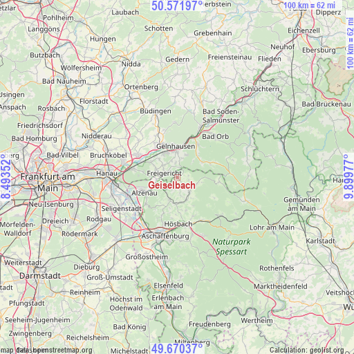
Geiselbach GPS coordinates[2]
50° 7' 23.844" North, 9° 11' 47.904" East
| Map corner | latitude | longitude |
|---|---|---|
| Upper-left | 50.57197°, | 8.49352° |
| Center: | 50.12329°, | 9.19664° |
| Lower-right: | 49.67037°, | 9.89977° |
| Map W x H: | 100.2×100.2 km | = 62.3×62.3mi |
| max Lat: | 55.01917° ⇑60.8% North |
| Geiselbach: | 50.12329° |
| min Lat: | ⇓39.2% South 47.40724° |
| min Long | Geiselbach | max Long |
| 5.92978° | 9.19664° | 14.98853° |
| W 37.5%⇐ | ⇒62.5% E |
Elevation
Elevation of Geiselbach is 283 m = 928 ft, and this is 33.9 m = 111 ft above average elevation for this country.
| Max E: |
1256 m = 4121 ft | 41.2% |
| Geiselbach | 283 m 928 ft | |
| Avg. | 249.1 m = 817 ft | |
Min E: |
-5 m = -16 ft | 58.8% |
See also: Germany elevation on elevation.city.
Geographical zone
Geiselbach is located in North temperate zone (between Tropic of Cancer and the Arctic Circle). Distance of this North polar circle is 1828 km =1135.9 mi to North.| Distance of | km | miles | from Geiselbach |
|---|---|---|---|
| North Pole | 4433.9 | 2755.1 | to North |
| Arctic Circle | 1828 | 1135.9 | to North |
| Tropic Cancer | 2967.3 | 1843.8 | to South |
| Equator | 5573.2 | 3463 | to South |


Nearby cities:
15 places around Geiselbach: (largest is in red/bold)
• Alzenau in Unterfranken
10.2 km =6.3 mi,  247°
247°
• Blankenbach
6.8 km =4.2 mi,  157°
157°
• Gelnhausen
8.7 km =5.4 mi,  355°
355°
• Heinrichsthal
11.9 km =7.4 mi,  119°
119°
• Johannesberg
10.9 km =6.8 mi,  200°
200°
• Kleinkahl
5 km =3.1 mi,  98°
98°
• Krombach
4.5 km =2.8 mi,  171°
171°
• Langenselbold
12.6 km =7.8 mi,  297°
297°
• Mömbris
6.5 km =4 mi, 201°
• Nieder-Gründau
11.6 km =7.2 mi,  327°
327°
• Rodenbach
12 km =7.5 mi,  284°
284°
• Sailauf
11.8 km =7.3 mi, 157°
• Schöllkrippen
5.5 km =3.4 mi,  139°
139°
• Sommerkahl
7.3 km =4.5 mi, 144°
• Wiesen
12.1 km =7.5 mi,  93°
93°
Sources, notices
• [Note1] Compared only with cities in Germany existing in our database
• [Src1] Map data: © OpenStreetMap contributors (CC-BY-SA)
• [Src2] Other city data from geonames.org with taken over terms of usage.
• [Src3] Geographical zone / Annual Mean Temperature by Robert A. Rohde @ Wikipedia
