Johannesberg geodata
Johannesberg (Bavaria) is a seat of a fourth-order administrative division; located in Germany in Europe/Berlin (GMT+2) time zone. With population of 3,914 people, there are 3345 cities with bigger population in this country. Compared to other cities in Germany, 63% of cities are located further ↑North; 63.3% of cities are located further →East and 68% of cities have lower elevation than Johannesberg. Note1
Administrative division(s):
- Level 1: Bavaria
- Level 2: Regierungsbezirk Unterfranken
- Level 3: Landkreis Aschaffenburg
- Level 4: Johannesberg


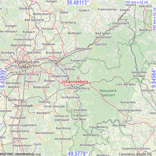
Johannesberg GPS coordinates[2]
50° 1' 53.724" North, 9° 8' 33.072" East
| Map corner | latitude | longitude |
|---|---|---|
| Upper-left | 50.48113°, | 8.43939° |
| Center: | 50.03159°, | 9.14252° |
| Lower-right: | 49.5778°, | 9.84564° |
| Map W x H: | 100.4×100.4 km | = 62.4×62.4mi |
| max Lat: | 55.01917° ⇑63% North |
| Johannesberg: | 50.03159° |
| min Lat: | ⇓37% South 47.40724° |
| min Long | Johannesberg | max Long |
| 5.92978° | 9.14252° | 14.98853° |
| W 36.7%⇐ | ⇒63.3% E |
Elevation
Elevation of Johannesberg is 342 m = 1122 ft, and this is 92.9 m = 305 ft above average elevation for this country.
| Max E: |
1256 m = 4121 ft | 32% |
| Johannesberg | 342 m 1122 ft | |
| Avg. | 249.1 m = 817 ft | |
Min E: |
-5 m = -16 ft | 68% |
See also: Germany elevation on elevation.city.
Geographical zone
Johannesberg is located in North temperate zone (between Tropic of Cancer and the Arctic Circle). Distance of this North polar circle is 1838.2 km =1142.2 mi to North.| Distance of | km | miles | from Johannesberg |
|---|---|---|---|
| North Pole | 4444.1 | 2761.4 | to North |
| Arctic Circle | 1838.2 | 1142.2 | to North |
| Tropic Cancer | 2957.1 | 1837.5 | to South |
| Equator | 5563 | 3456.7 | to South |


Nearby cities:
15 places around Johannesberg: (largest is in red/bold)
• Alzenau in Unterfranken
8.5 km =5.3 mi,  318°
318°
• Aschaffenburg
6.1 km =3.8 mi,  173°
173°
• Blankenbach
7.6 km =4.7 mi,  58°
58°
• Glattbach
3.6 km =2.2 mi, 171°
• Goldbach
4.7 km =2.9 mi,  140°
140°
• Haibach
8.8 km =5.5 mi,  148°
148°
• Hösbach
5.4 km =3.4 mi,  120°
120°
• Kleinostheim
6.5 km =4 mi,  237°
237°
• Krombach
7.3 km =4.5 mi,  38°
38°
• Mainaschaff
6.7 km =4.2 mi,  214°
214°
• Mömbris
4.4 km =2.7 mi,  19°
19°
• Sailauf
8.4 km =5.2 mi,  95°
95°
• Schöllkrippen
9.6 km =6 mi,  51°
51°
• Sommerkahl
9.2 km =5.7 mi, 62°
• Stockstadt am Main
8.5 km =5.3 mi,  216°
216°
Sources, notices
• [Note1] Compared only with cities in Germany existing in our database
• [Src1] Map data: © OpenStreetMap contributors (CC-BY-SA)
• [Src2] Other city data from geonames.org with taken over terms of usage.
• [Src3] Geographical zone / Annual Mean Temperature by Robert A. Rohde @ Wikipedia
