Clausen geodata
Clausen (Rheinland-Pfalz) is a seat of a fourth-order administrative division; located in Germany in Europe/Berlin (GMT+2) time zone. With population of 1,626 people, there are 5643 cities with bigger population in this country. Compared to other cities in Germany, 79.3% of cities are located further ↑North; 83.5% of cities are located further →East and 75.6% of cities have lower elevation than Clausen. Note1


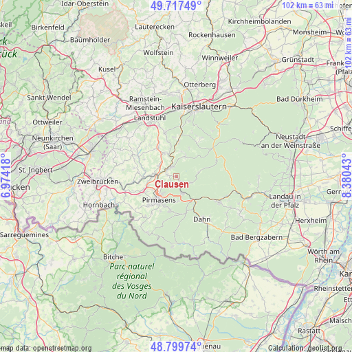
Clausen GPS coordinates[2]
49° 15' 38.7" North, 7° 40' 38.28" East
| Map corner | latitude | longitude |
|---|---|---|
| Upper-left | 49.71749°, | 6.97418° |
| Center: | 49.26075°, | 7.6773° |
| Lower-right: | 48.79974°, | 8.38043° |
| Map W x H: | 102×102 km | = 63.4×63.4mi |
| max Lat: | 55.01917° ⇑79.3% North |
| Clausen: | 49.26075° |
| min Lat: | ⇓20.7% South 47.40724° |
| min Long | Clausen | max Long |
| 5.92978° | 7.6773° | 14.98853° |
| W 16.5%⇐ | ⇒83.5% E |
Elevation
Elevation of Clausen is 402 m = 1319 ft, and this is 152.9 m = 502 ft above average elevation for this country.
| Max E: |
1256 m = 4121 ft | 24.4% |
| Clausen | 402 m 1319 ft | |
| Avg. | 249.1 m = 817 ft | |
Min E: |
-5 m = -16 ft | 75.6% |
See also: Germany elevation on elevation.city.
Geographical zone
Clausen is located in North temperate zone (between Tropic of Cancer and the Arctic Circle). Distance of this North polar circle is 1923.9 km =1195.5 mi to North.| Distance of | km | miles | from Clausen |
|---|---|---|---|
| North Pole | 4529.8 | 2814.7 | to North |
| Arctic Circle | 1923.9 | 1195.5 | to North |
| Tropic Cancer | 2871.4 | 1784.2 | to South |
| Equator | 5477.3 | 3403.4 | to South |


Nearby cities:
15 places around Clausen: (largest is in red/bold)
• Donsieders
2.6 km =1.6 mi,  281°
281°
• Geiselberg
7.4 km =4.6 mi,  11°
11°
• Heltersberg
6.8 km =4.2 mi,  24°
24°
• Hermersberg
7 km =4.3 mi,  332°
332°
• Horbach
8.3 km =5.2 mi,  346°
346°
• Höheinöd
6 km =3.7 mi,  302°
302°
• Höhfröschen
8.1 km =5 mi,  261°
261°
• Leimen
6.8 km =4.2 mi,  77°
77°
• Merzalben
4.3 km =2.7 mi,  114°
114°
• Münchweiler an der Rodalbe
5.1 km =3.2 mi,  158°
158°
• Rodalben
3.6 km =2.2 mi,  229°
229°
• Ruppertsweiler
7.1 km =4.4 mi,  172°
172°
• Steinalben
6.5 km =4 mi,  342°
342°
• Thaleischweiler-Fröschen
6.9 km =4.3 mi, 275°
• Waldfischbach-Burgalben
2.6 km =1.6 mi, 342°
Sources, notices
• [Note1] Compared only with cities in Germany existing in our database
• [Src1] Map data: © OpenStreetMap contributors (CC-BY-SA)
• [Src2] Other city data from geonames.org with taken over terms of usage.
• [Src3] Geographical zone / Annual Mean Temperature by Robert A. Rohde @ Wikipedia
