Schkölen geodata
Schkölen (Thuringia) is a populated place; located in Germany in Europe/Berlin (GMT+2) time zone. With population of 2,909 people, there are 4082 cities with bigger population in this country. Compared to other cities in Germany, 58.8% of cities are located further ↓South; 79.1% of cities are located further ←West and 52.1% of cities have higher elevation than Schkölen. Note1


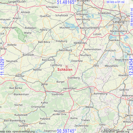
Schkölen GPS coordinates[2]
51° 2' 29.976" North, 11° 49' 17.076" East
| Map corner | latitude | longitude |
|---|---|---|
| Upper-left | 51.48165°, | 11.11829° |
| Center: | 51.04166°, | 11.82141° |
| Lower-right: | 50.59745°, | 12.52454° |
| Map W x H: | 98.3×98.3 km | = 61.1×61.1mi |
| max Lat: | 55.01917° ⇑41.2% North |
| Schkölen: | 51.04166° |
| min Lat: | ⇓58.8% South 47.40724° |
| min Long | Schkölen | max Long |
| 5.92978° | 11.82141° | 14.98853° |
| W 79.1%⇐ | ⇒20.9% E |
Elevation
Elevation of Schkölen is 211 m = 692 ft, and this is 38.1 m = 125 ft below average elevation for this country.
| Max E: |
1256 m = 4121 ft | 52.1% |
| Avg. | 249.1 m = 817 ft | |
| Schkölen | 211 m = 692 ft | |
Min E: |
-5 m = -16 ft | 47.9% |
See also: Germany elevation on elevation.city.
Geographical zone
Schkölen is located in North temperate zone (between Tropic of Cancer and the Arctic Circle). Distance of this North polar circle is 1725.9 km =1072.4 mi to North.| Distance of | km | miles | from Schkölen |
|---|---|---|---|
| North Pole | 4331.8 | 2691.7 | to North |
| Arctic Circle | 1725.9 | 1072.4 | to North |
| Tropic Cancer | 3069.4 | 1907.2 | to South |
| Equator | 5675.3 | 3526.5 | to South |


Nearby cities:
15 places around Schkölen: (largest is in red/bold)
• Camburg
8 km =5 mi,  280°
280°
• Frauenprießnitz
6.8 km =4.2 mi,  245°
245°
• Görschen
9.6 km =6 mi,  35°
35°
• Gösen
6.3 km =3.9 mi,  136°
136°
• Hainspitz
9 km =5.6 mi,  172°
172°
• Mertendorf
5.3 km =3.3 mi,  209°
209°
• Mertendorf
9 km =5.6 mi,  16°
16°
• Molau
3.4 km =2.1 mi,  301°
301°
• Osterfeld
8.7 km =5.4 mi,  60°
60°
• Petersberg
6.5 km =4 mi, 172°
• Rauschwitz
8.5 km =5.3 mi,  190°
190°
• Tautenburg
8.7 km =5.4 mi,  237°
237°
• Thierschneck
3.9 km =2.4 mi,  256°
256°
• Waldau
8.2 km =5.1 mi,  72°
72°
• Walpernhain
9.4 km =5.8 mi,  107°
107°
Sources, notices
• [Note1] Compared only with cities in Germany existing in our database
• [Src1] Map data: © OpenStreetMap contributors (CC-BY-SA)
• [Src2] Other city data from geonames.org with taken over terms of usage.
• [Src3] Geographical zone / Annual Mean Temperature by Robert A. Rohde @ Wikipedia
