Hainspitz geodata
Hainspitz (Thuringia) is a seat of a fourth-order administrative division; located in Germany in Europe/Berlin (GMT+2) time zone. With population of 741 people, there are 8146 cities with bigger population in this country. Compared to other cities in Germany, 57.4% of cities are located further ↓South; 79.3% of cities are located further ←West and 56.7% of cities have lower elevation than Hainspitz. Note1


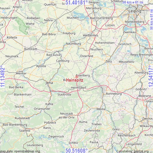
Hainspitz GPS coordinates[2]
50° 57' 39.816" North, 11° 50' 16.944" East
| Map corner | latitude | longitude |
|---|---|---|
| Upper-left | 51.40181°, | 11.13492° |
| Center: | 50.96106°, | 11.83804° |
| Lower-right: | 50.51608°, | 12.54117° |
| Map W x H: | 98.5×98.5 km | = 61.2×61.2mi |
| max Lat: | 55.01917° ⇑42.6% North |
| Hainspitz: | 50.96106° |
| min Lat: | ⇓57.4% South 47.40724° |
| min Long | Hainspitz | max Long |
| 5.92978° | 11.83804° | 14.98853° |
| W 79.3%⇐ | ⇒20.7% E |
Elevation
Elevation of Hainspitz is 270 m = 886 ft, and this is 20.9 m = 69 ft above average elevation for this country.
| Max E: |
1256 m = 4121 ft | 43.3% |
| Hainspitz | 270 m 886 ft | |
| Avg. | 249.1 m = 817 ft | |
Min E: |
-5 m = -16 ft | 56.7% |
See also: Germany elevation on elevation.city.
Geographical zone
Hainspitz is located in North temperate zone (between Tropic of Cancer and the Arctic Circle). Distance of this North polar circle is 1734.8 km =1078 mi to North.| Distance of | km | miles | from Hainspitz |
|---|---|---|---|
| North Pole | 4340.7 | 2697.2 | to North |
| Arctic Circle | 1734.8 | 1078 | to North |
| Tropic Cancer | 3060.4 | 1901.6 | to South |
| Equator | 5666.3 | 3520.9 | to South |


Nearby cities:
15 places around Hainspitz: (largest is in red/bold)
• Bad Klosterlausnitz
5.3 km =3.3 mi,  157°
157°
• Bobeck
7.2 km =4.5 mi,  206°
206°
• Bürgel
6.1 km =3.8 mi,  249°
249°
• Eisenberg
4.6 km =2.9 mi,  79°
79°
• Gösen
5.4 km =3.4 mi,  36°
36°
• Hermsdorf
7.2 km =4.5 mi,  170°
170°
• Mertendorf
5.8 km =3.6 mi,  318°
318°
• Petersberg
2.5 km =1.6 mi,  352°
352°
• Poxdorf
6.2 km =3.9 mi,  275°
275°
• Rauda
7.4 km =4.6 mi,  97°
97°
• Rauschwitz
2.7 km =1.7 mi, 283°
• Serba
1.9 km =1.2 mi,  230°
230°
• Tautenhain
7 km =4.3 mi,  125°
125°
• Waldeck
6.2 km =3.9 mi,  217°
217°
• Weißenborn
5 km =3.1 mi,  144°
144°
Sources, notices
• [Note1] Compared only with cities in Germany existing in our database
• [Src1] Map data: © OpenStreetMap contributors (CC-BY-SA)
• [Src2] Other city data from geonames.org with taken over terms of usage.
• [Src3] Geographical zone / Annual Mean Temperature by Robert A. Rohde @ Wikipedia
