Camburg geodata
Camburg (Thuringia) is a populated place; located in Germany in Europe/Berlin (GMT+2) time zone. With population of 2,958 people, there are 4040 cities with bigger population in this country. Compared to other cities in Germany, 59.1% of cities are located further ↓South; 77.4% of cities are located further ←West and 63.9% of cities have higher elevation than Camburg. Note1


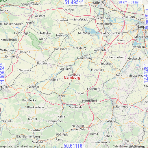
Camburg GPS coordinates[2]
51° 3' 18.864" North, 11° 42' 34.812" East
| Map corner | latitude | longitude |
|---|---|---|
| Upper-left | 51.4951°, | 11.00655° |
| Center: | 51.05524°, | 11.70967° |
| Lower-right: | 50.61116°, | 12.4128° |
| Map W x H: | 98.3×98.3 km | = 61.1×61.1mi |
| max Lat: | 55.01917° ⇑40.9% North |
| Camburg: | 51.05524° |
| min Lat: | ⇓59.1% South 47.40724° |
| min Long | Camburg | max Long |
| 5.92978° | 11.70967° | 14.98853° |
| W 77.4%⇐ | ⇒22.6% E |
Elevation
Elevation of Camburg is 127 m = 417 ft, and this is 122.1 m = 401 ft below average elevation for this country.
| Max E: |
1256 m = 4121 ft | 63.9% |
| Avg. | 249.1 m = 817 ft | |
| Camburg | 127 m = 417 ft | |
Min E: |
-5 m = -16 ft | 36.1% |
See also: Germany elevation on elevation.city.
Geographical zone
Camburg is located in North temperate zone (between Tropic of Cancer and the Arctic Circle). Distance of this North polar circle is 1724.4 km =1071.5 mi to North.| Distance of | km | miles | from Camburg |
|---|---|---|---|
| North Pole | 4330.3 | 2690.7 | to North |
| Arctic Circle | 1724.4 | 1071.5 | to North |
| Tropic Cancer | 3070.9 | 1908.2 | to South |
| Equator | 5676.8 | 3527.4 | to South |


Nearby cities:
15 places around Camburg: (largest is in red/bold)
• Bad Kösen
8.8 km =5.5 mi,  5°
5°
• Bad Sulza
7 km =4.3 mi,  302°
302°
• Dornburg
6.2 km =3.9 mi,  211°
211°
• Frauenprießnitz
4.6 km =2.9 mi,  158°
158°
• Großheringen
6 km =3.7 mi,  331°
331°
• Hainichen
8.9 km =5.5 mi,  226°
226°
• Lengefeld
6.8 km =4.2 mi,  1°
1°
• Mertendorf
8 km =5 mi,  140°
140°
• Molau
4.9 km =3 mi,  86°
86°
• Schkölen
8 km =5 mi,  100°
100°
• Schmiedehausen
3.3 km =2.1 mi,  292°
292°
• Tautenburg
6.2 km =3.9 mi,  175°
175°
• Thierschneck
4.7 km =2.9 mi,  121°
121°
• Wichmar
3.1 km =1.9 mi,  217°
217°
• Zimmern
8.1 km =5 mi, 220°
Sources, notices
• [Note1] Compared only with cities in Germany existing in our database
• [Src1] Map data: © OpenStreetMap contributors (CC-BY-SA)
• [Src2] Other city data from geonames.org with taken over terms of usage.
• [Src3] Geographical zone / Annual Mean Temperature by Robert A. Rohde @ Wikipedia
