Schackendorf geodata
Schackendorf (Schleswig-Holstein) is a seat of a fourth-order administrative division; located in Germany in Europe/Berlin (GMT+2) time zone. With population of 784 people, there are 7970 cities with bigger population in this country. Compared to other cities in Germany, 92.2% of cities are located further ↓South; 54.8% of cities are located further ←West and 84.1% of cities have higher elevation than Schackendorf. Note1
Administrative division(s):
- Level 1: Schleswig-Holstein
- Level 3: Kreis Segeberg
- Level 4: Schackendorf


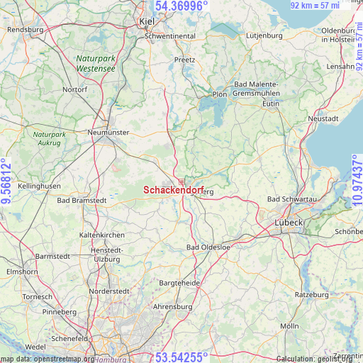
Schackendorf GPS coordinates[2]
53° 57' 29.916" North, 10° 16' 16.464" East
| Map corner | latitude | longitude |
|---|---|---|
| Upper-left | 54.36996°, | 9.56812° |
| Center: | 53.95831°, | 10.27124° |
| Lower-right: | 53.54255°, | 10.97437° |
| Map W x H: | 92×92 km | = 57.2×57.2mi |
| max Lat: | 55.01917° ⇑7.8% North |
| Schackendorf: | 53.95831° |
| min Lat: | ⇓92.2% South 47.40724° |
| min Long | Schackendorf | max Long |
| 5.92978° | 10.27124° | 14.98853° |
| W 54.8%⇐ | ⇒45.2% E |
Elevation
Elevation of Schackendorf is 37 m = 121 ft, and this is 212.1 m = 696 ft below average elevation for this country.
| Max E: |
1256 m = 4121 ft | 84.1% |
| Avg. | 249.1 m = 817 ft | |
| Schackendorf | 37 m = 121 ft | |
Min E: |
-5 m = -16 ft | 15.9% |
See also: Germany elevation on elevation.city.
Geographical zone
Schackendorf is located in North temperate zone (between Tropic of Cancer and the Arctic Circle). Distance of this North polar circle is 1401.6 km =870.9 mi to North.| Distance of | km | miles | from Schackendorf |
|---|---|---|---|
| North Pole | 4007.5 | 2490.1 | to North |
| Arctic Circle | 1401.6 | 870.9 | to North |
| Tropic Cancer | 3393.7 | 2108.7 | to South |
| Equator | 5999.6 | 3728 | to South |


Nearby cities:
15 places around Schackendorf: (largest is in red/bold)
• Bad Segeberg
2.6 km =1.6 mi,  129°
129°
• Blunk
6.3 km =3.9 mi,  26°
26°
• Daldorf
6.6 km =4.1 mi,  347°
347°
• Fahrenkrug
1.7 km =1.1 mi,  236°
236°
• Groß Rönnau
3.1 km =1.9 mi,  72°
72°
• Högersdorf
4.7 km =2.9 mi,  170°
170°
• Klein Gladebrügge
5.5 km =3.4 mi,  147°
147°
• Klein Rönnau
3.1 km =1.9 mi, 72°
• Kükels
6.9 km =4.3 mi,  200°
200°
• Mözen
4.8 km =3 mi, 196°
• Negernbötel
3.1 km =1.9 mi,  333°
333°
• Schwissel
6.8 km =4.2 mi,  163°
163°
• Stipsdorf
4.2 km =2.6 mi,  102°
102°
• Wahlstedt
4.3 km =2.7 mi,  260°
260°
• Wittenborn
5.2 km =3.2 mi,  219°
219°
Sources, notices
• [Note1] Compared only with cities in Germany existing in our database
• [Src1] Map data: © OpenStreetMap contributors (CC-BY-SA)
• [Src2] Other city data from geonames.org with taken over terms of usage.
• [Src3] Geographical zone / Annual Mean Temperature by Robert A. Rohde @ Wikipedia
