Blunk geodata
Blunk (Schleswig-Holstein) is a seat of a fourth-order administrative division; located in Germany in Europe/Berlin (GMT+2) time zone. With population of 598 people, there are 8837 cities with bigger population in this country. Compared to other cities in Germany, 92.7% of cities are located further ↓South; 55.6% of cities are located further ←West and 77% of cities have higher elevation than Blunk. Note1


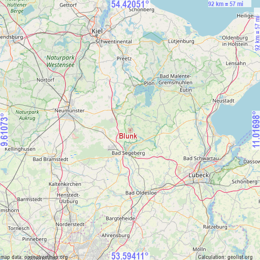
Blunk GPS coordinates[2]
54° 0' 33.696" North, 10° 18' 49.86" East
| Map corner | latitude | longitude |
|---|---|---|
| Upper-left | 54.42051°, | 9.61073° |
| Center: | 54.00936°, | 10.31385° |
| Lower-right: | 53.59411°, | 11.01698° |
| Map W x H: | 91.9×91.9 km | = 57.1×57.1mi |
| max Lat: | 55.01917° ⇑7.3% North |
| Blunk: | 54.00936° |
| min Lat: | ⇓92.7% South 47.40724° |
| min Long | Blunk | max Long |
| 5.92978° | 10.31385° | 14.98853° |
| W 55.6%⇐ | ⇒44.4% E |
Elevation
Elevation of Blunk is 56 m = 184 ft, and this is 193.1 m = 634 ft below average elevation for this country.
| Max E: |
1256 m = 4121 ft | 77% |
| Avg. | 249.1 m = 817 ft | |
| Blunk | 56 m = 184 ft | |
Min E: |
-5 m = -16 ft | 23% |
See also: Germany elevation on elevation.city.
Geographical zone
Blunk is located in North temperate zone (between Tropic of Cancer and the Arctic Circle). Distance of this North polar circle is 1395.9 km =867.4 mi to North.| Distance of | km | miles | from Blunk |
|---|---|---|---|
| North Pole | 4001.8 | 2486.6 | to North |
| Arctic Circle | 1395.9 | 867.4 | to North |
| Tropic Cancer | 3399.4 | 2112.3 | to South |
| Equator | 6005.3 | 3731.5 | to South |


Nearby cities:
15 places around Blunk: (largest is in red/bold)
• Bad Segeberg
7.4 km =4.6 mi,  185°
185°
• Daldorf
4.3 km =2.7 mi,  281°
281°
• Damsdorf
6.4 km =4 mi,  1°
1°
• Fahrenkrug
7.8 km =4.8 mi,  212°
212°
• Groß Rönnau
4.8 km =3 mi,  177°
177°
• Klein Rönnau
4.8 km =3 mi, 177°
• Negernbötel
5.1 km =3.2 mi,  235°
235°
• Nehms
3.5 km =2.2 mi,  76°
76°
• Schackendorf
6.3 km =3.9 mi, 206°
• Seedorf
8.1 km =5 mi,  56°
56°
• Stipsdorf
6.7 km =4.2 mi,  169°
169°
• Tarbek
5.5 km =3.4 mi,  325°
325°
• Tensfeld
3.7 km =2.3 mi, 4°
• Trappenkamp
7.3 km =4.5 mi,  297°
297°
• Wensin
7.3 km =4.5 mi,  113°
113°
Sources, notices
• [Note1] Compared only with cities in Germany existing in our database
• [Src1] Map data: © OpenStreetMap contributors (CC-BY-SA)
• [Src2] Other city data from geonames.org with taken over terms of usage.
• [Src3] Geographical zone / Annual Mean Temperature by Robert A. Rohde @ Wikipedia
