Sagard geodata
Sagard (Mecklenburg-Vorpommern) is a populated place; located in Germany in Europe/Berlin (GMT+2) time zone. With population of 2,859 people, there are 4128 cities with bigger population in this country. Compared to other cities in Germany, 98.2% of cities are located further ↓South; 96.1% of cities are located further ←West and 88.3% of cities have higher elevation than Sagard. Note1
Administrative division(s):
- Level 1: Mecklenburg-Vorpommern
- Level 3: Vorpommern-Rügen
- Level 4: Sagard


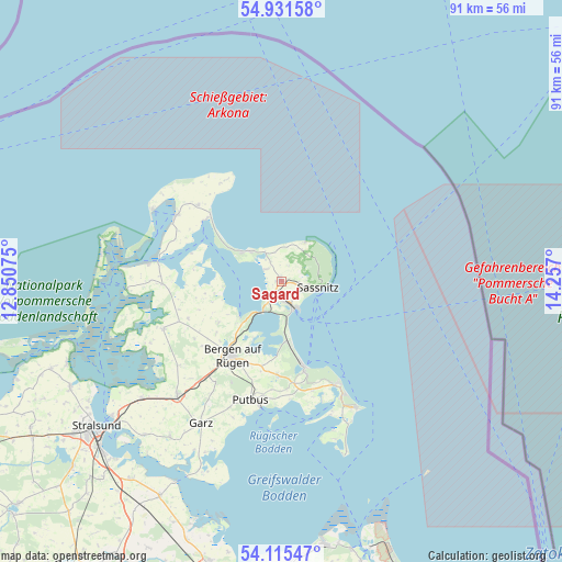
Sagard GPS coordinates[2]
54° 31' 32.016" North, 13° 33' 13.932" East
| Map corner | latitude | longitude |
|---|---|---|
| Upper-left | 54.93158°, | 12.85075° |
| Center: | 54.52556°, | 13.55387° |
| Lower-right: | 54.11547°, | 14.257° |
| Map W x H: | 90.7×90.7 km | = 56.4×56.4mi |
| max Lat: | 55.01917° ⇑1.8% North |
| Sagard: | 54.52556° |
| min Lat: | ⇓98.2% South 47.40724° |
| min Long | Sagard | max Long |
| 5.92978° | 13.55387° | 14.98853° |
| W 96.1%⇐ | ⇒3.9% E |
Elevation
Elevation of Sagard is 26 m = 85 ft, and this is 223.1 m = 732 ft below average elevation for this country.
| Max E: |
1256 m = 4121 ft | 88.3% |
| Avg. | 249.1 m = 817 ft | |
| Sagard | 26 m = 85 ft | |
Min E: |
-5 m = -16 ft | 11.7% |
See also: Germany elevation on elevation.city.
Geographical zone
Sagard is located in North temperate zone (between Tropic of Cancer and the Arctic Circle). Distance of this North polar circle is 1338.5 km =831.7 mi to North.| Distance of | km | miles | from Sagard |
|---|---|---|---|
| North Pole | 3944.4 | 2450.9 | to North |
| Arctic Circle | 1338.5 | 831.7 | to North |
| Tropic Cancer | 3456.8 | 2148 | to South |
| Equator | 6062.7 | 3767.2 | to South |


Nearby cities:
15 places around Sagard: (largest is in red/bold)
• Altenkirchen
18.3 km =11.4 mi,  312°
312°
• Bergen auf Rügen
14.2 km =8.8 mi,  213°
213°
• Breege
15.8 km =9.8 mi, 308°
• Gingst
20.6 km =12.8 mi,  248°
248°
• Glowe
7.5 km =4.7 mi, 310°
• Lohme
7.4 km =4.6 mi,  29°
29°
• Ostseebad Binz
14.4 km =8.9 mi,  165°
165°
• Ostseebad Sellin
18.7 km =11.6 mi,  151°
151°
• Parchtitz
14 km =8.7 mi,  225°
225°
• Patzig
12.2 km =7.6 mi,  236°
236°
• Putbus
19.6 km =12.2 mi,  194°
194°
• Saßnitz
6 km =3.7 mi,  100°
100°
• Sehlen
19.4 km =12.1 mi, 213°
• Trent
19.2 km =11.9 mi,  268°
268°
• Wiek
20 km =12.4 mi,  301°
301°
Sources, notices
• [Note1] Compared only with cities in Germany existing in our database
• [Src1] Map data: © OpenStreetMap contributors (CC-BY-SA)
• [Src2] Other city data from geonames.org with taken over terms of usage.
• [Src3] Geographical zone / Annual Mean Temperature by Robert A. Rohde @ Wikipedia
