Patzig geodata
Patzig (Mecklenburg-Vorpommern) is a populated place; located in Germany in Europe/Berlin (GMT+2) time zone. With population of 510 people, there are 9326 cities with bigger population in this country. Compared to other cities in Germany, 97.8% of cities are located further ↓South; 95.1% of cities are located further ←West and 86.3% of cities have higher elevation than Patzig. Note1
Administrative division(s):
- Level 1: Mecklenburg-Vorpommern
- Level 3: Vorpommern-Rügen
- Level 4: Patzig


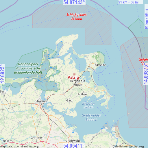
Patzig GPS coordinates[2]
54° 27' 53.316" North, 13° 23' 44.232" East
| Map corner | latitude | longitude |
|---|---|---|
| Upper-left | 54.87143°, | 12.6925° |
| Center: | 54.46481°, | 13.39562° |
| Lower-right: | 54.05411°, | 14.09875° |
| Map W x H: | 90.9×90.9 km | = 56.5×56.5mi |
| max Lat: | 55.01917° ⇑2.2% North |
| Patzig: | 54.46481° |
| min Lat: | ⇓97.8% South 47.40724° |
| min Long | Patzig | max Long |
| 5.92978° | 13.39562° | 14.98853° |
| W 95.1%⇐ | ⇒4.9% E |
Elevation
Elevation of Patzig is 32 m = 105 ft, and this is 217.1 m = 712 ft below average elevation for this country.
| Max E: |
1256 m = 4121 ft | 86.3% |
| Avg. | 249.1 m = 817 ft | |
| Patzig | 32 m = 105 ft | |
Min E: |
-5 m = -16 ft | 13.7% |
See also: Germany elevation on elevation.city.
Geographical zone
Patzig is located in North temperate zone (between Tropic of Cancer and the Arctic Circle). Distance of this North polar circle is 1345.3 km =835.9 mi to North.| Distance of | km | miles | from Patzig |
|---|---|---|---|
| North Pole | 3951.1 | 2455.1 | to North |
| Arctic Circle | 1345.3 | 835.9 | to North |
| Tropic Cancer | 3450 | 2143.7 | to South |
| Equator | 6055.9 | 3763 | to South |


Nearby cities:
15 places around Patzig: (largest is in red/bold)
• Bergen auf Rügen
5.7 km =3.5 mi,  154°
154°
• Breege
16.8 km =10.4 mi,  352°
352°
• Dreschvitz
9.5 km =5.9 mi,  223°
223°
• Garz
16.5 km =10.3 mi,  190°
190°
• Gingst
9 km =5.6 mi,  264°
264°
• Glowe
12.4 km =7.7 mi,  21°
21°
• Ostseebad Binz
15.7 km =9.8 mi,  117°
117°
• Parchtitz
3 km =1.9 mi,  176°
176°
• Putbus
13.3 km =8.3 mi,  156°
156°
• Sagard
12.2 km =7.6 mi,  56°
56°
• Samtens
13.9 km =8.6 mi,  208°
208°
• Schaprode
15.8 km =9.8 mi,  290°
290°
• Sehlen
9.5 km =5.9 mi, 182°
• Trent
11 km =6.8 mi,  304°
304°
• Ummanz
12.1 km =7.5 mi, 258°
Sources, notices
• [Note1] Compared only with cities in Germany existing in our database
• [Src1] Map data: © OpenStreetMap contributors (CC-BY-SA)
• [Src2] Other city data from geonames.org with taken over terms of usage.
• [Src3] Geographical zone / Annual Mean Temperature by Robert A. Rohde @ Wikipedia
