Kastel-Staadt geodata
Kastel-Staadt (Rheinland-Pfalz) is a seat of a fourth-order administrative division; located in Germany in Europe/Berlin (GMT+2) time zone. With population of 378 people, there are 9764 cities with bigger population in this country. Compared to other cities in Germany, 74.5% of cities are located further ↑North; 97.4% of cities are located further →East and 57.5% of cities have lower elevation than Kastel-Staadt. Note1
Administrative division(s):
- Level 1: Rheinland-Pfalz
- Level 3: Landkreis Trier-Saarburg
- Level 4: Kastel-Staadt


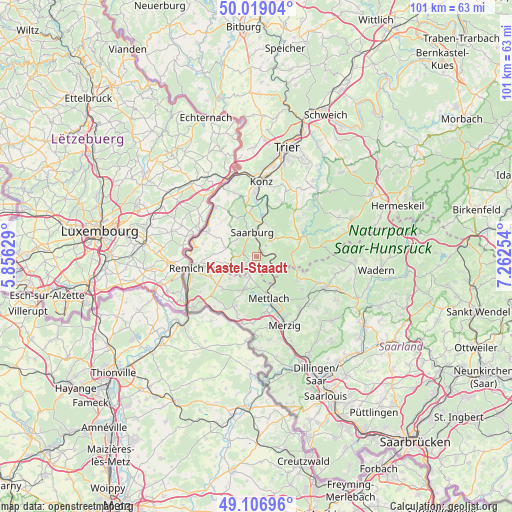
Kastel-Staadt GPS coordinates[2]
49° 33' 54.468" North, 6° 33' 33.912" East
| Map corner | latitude | longitude |
|---|---|---|
| Upper-left | 50.01904°, | 5.85629° |
| Center: | 49.56513°, | 6.55942° |
| Lower-right: | 49.10696°, | 7.26254° |
| Map W x H: | 101.4×101.4 km | = 63×63mi |
| max Lat: | 55.01917° ⇑74.5% North |
| Kastel-Staadt: | 49.56513° |
| min Lat: | ⇓25.5% South 47.40724° |
| min Long | Kastel-Staadt | max Long |
| 5.92978° | 6.55942° | 14.98853° |
| W 2.6%⇐ | ⇒97.4% E |
Elevation
Elevation of Kastel-Staadt is 275 m = 902 ft, and this is 25.9 m = 85 ft above average elevation for this country.
| Max E: |
1256 m = 4121 ft | 42.5% |
| Kastel-Staadt | 275 m 902 ft | |
| Avg. | 249.1 m = 817 ft | |
Min E: |
-5 m = -16 ft | 57.5% |
See also: Germany elevation on elevation.city.
Geographical zone
Kastel-Staadt is located in North temperate zone (between Tropic of Cancer and the Arctic Circle). Distance of this North polar circle is 1890 km =1174.4 mi to North.| Distance of | km | miles | from Kastel-Staadt |
|---|---|---|---|
| North Pole | 4495.9 | 2793.6 | to North |
| Arctic Circle | 1890 | 1174.4 | to North |
| Tropic Cancer | 2905.2 | 1805.2 | to South |
| Equator | 5511.1 | 3424.4 | to South |


Nearby cities:
15 places around Kastel-Staadt: (largest is in red/bold)
• Ayl
7.6 km =4.7 mi,  354°
354°
• Fisch
7.9 km =4.9 mi,  316°
316°
• Freudenburg
3.1 km =1.9 mi,  218°
218°
• Irsch
5.1 km =3.2 mi,  30°
30°
• Kirf
5.7 km =3.5 mi,  252°
252°
• Merzkirchen
5.8 km =3.6 mi,  290°
290°
• Ockfen
6 km =3.7 mi,  16°
16°
• Orscholz
7 km =4.3 mi,  200°
200°
• Saarburg
4.7 km =2.9 mi, 346°
• Saarhölzbach
6.5 km =4 mi,  147°
147°
• Schoden
7.8 km =4.8 mi,  12°
12°
• Serrig
1.6 km =1 mi,  44°
44°
• Taben-Rodt
2.4 km =1.5 mi,  134°
134°
• Trassem
2.9 km =1.8 mi,  301°
301°
• Weiten
4.1 km =2.5 mi, 199°
Sources, notices
• [Note1] Compared only with cities in Germany existing in our database
• [Src1] Map data: © OpenStreetMap contributors (CC-BY-SA)
• [Src2] Other city data from geonames.org with taken over terms of usage.
• [Src3] Geographical zone / Annual Mean Temperature by Robert A. Rohde @ Wikipedia
