Rüdesheim geodata
Rüdesheim (Rheinland-Pfalz) is a seat of a fourth-order administrative division; located in Germany in Europe/Berlin (GMT+2) time zone. With population of 2,408 people, there are 4551 cities with bigger population in this country. Compared to other cities in Germany, 67.8% of cities are located further ↑North; 80.7% of cities are located further →East and 62.7% of cities have higher elevation than Rüdesheim. Note1
Administrative division(s):
- Level 1: Rheinland-Pfalz
- Level 3: Landkreis Bad Kreuznach
- Level 4: Rüdesheim


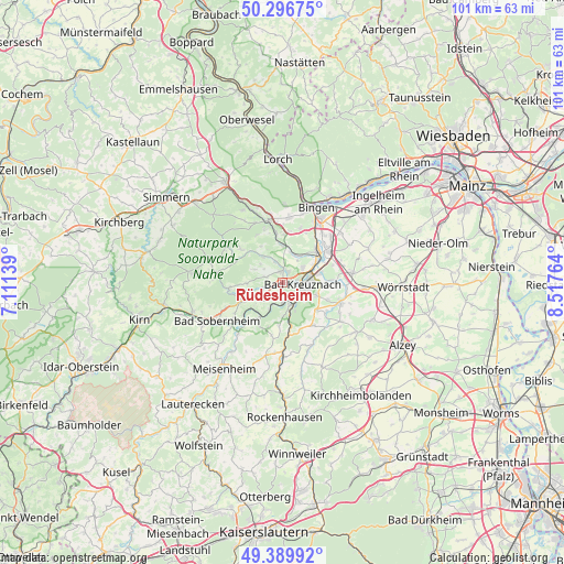
Rüdesheim GPS coordinates[2]
49° 50' 43.656" North, 7° 48' 52.272" East
| Map corner | latitude | longitude |
|---|---|---|
| Upper-left | 50.29675°, | 7.11139° |
| Center: | 49.84546°, | 7.81452° |
| Lower-right: | 49.38992°, | 8.51764° |
| Map W x H: | 100.8×100.8 km | = 62.6×62.6mi |
| max Lat: | 55.01917° ⇑67.8% North |
| Rüdesheim: | 49.84546° |
| min Lat: | ⇓32.2% South 47.40724° |
| min Long | Rüdesheim | max Long |
| 5.92978° | 7.81452° | 14.98853° |
| W 19.3%⇐ | ⇒80.7% E |
Elevation
Elevation of Rüdesheim is 134 m = 440 ft, and this is 115.1 m = 378 ft below average elevation for this country.
| Max E: |
1256 m = 4121 ft | 62.7% |
| Avg. | 249.1 m = 817 ft | |
| Rüdesheim | 134 m = 440 ft | |
Min E: |
-5 m = -16 ft | 37.3% |
See also: Germany elevation on elevation.city.
Geographical zone
Rüdesheim is located in North temperate zone (between Tropic of Cancer and the Arctic Circle). Distance of this North polar circle is 1858.9 km =1155.1 mi to North.| Distance of | km | miles | from Rüdesheim |
|---|---|---|---|
| North Pole | 4464.8 | 2774.3 | to North |
| Arctic Circle | 1858.9 | 1155.1 | to North |
| Tropic Cancer | 2936.4 | 1824.6 | to South |
| Equator | 5542.3 | 3443.8 | to South |


Nearby cities:
15 places around Rüdesheim: (largest is in red/bold)
• Bad Kreuznach
3.8 km =2.4 mi,  96°
96°
• Bad Münster am Stein-Ebernburg
4.4 km =2.7 mi,  149°
149°
• Braunweiler
5.2 km =3.2 mi,  297°
297°
• Gutenberg
4.3 km =2.7 mi,  346°
346°
• Hargesheim
2.1 km =1.3 mi,  28°
28°
• Hüffelsheim
3.4 km =2.1 mi,  198°
198°
• Mandel
3.2 km =2 mi,  289°
289°
• Niederhausen
5.5 km =3.4 mi, 203°
• Norheim
3.8 km =2.4 mi,  179°
179°
• Roxheim
2.1 km =1.3 mi, 350°
• Sankt Katharinen
4.2 km =2.6 mi, 304°
• Sommerloch
5.3 km =3.3 mi,  312°
312°
• Traisen
3.2 km =2 mi, 177°
• Wallhausen
5.4 km =3.4 mi,  320°
320°
• Weinsheim
3.7 km =2.3 mi,  248°
248°
Sources, notices
• [Note1] Compared only with cities in Germany existing in our database
• [Src1] Map data: © OpenStreetMap contributors (CC-BY-SA)
• [Src2] Other city data from geonames.org with taken over terms of usage.
• [Src3] Geographical zone / Annual Mean Temperature by Robert A. Rohde @ Wikipedia
