Beesenstedt geodata
Beesenstedt (Saxony-Anhalt) is a populated place; located in Germany in Europe/Berlin (GMT+2) time zone. With population of 1,287 people, there are 6341 cities with bigger population in this country. Compared to other cities in Germany, 67.1% of cities are located further ↓South; 77.6% of cities are located further ←West and 57.4% of cities have higher elevation than Beesenstedt. Note1


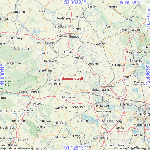
Beesenstedt GPS coordinates[2]
51° 34' 5.808" North, 11° 43' 59.628" East
| Map corner | latitude | longitude |
|---|---|---|
| Upper-left | 52.00323°, | 11.03011° |
| Center: | 51.56828°, | 11.73323° |
| Lower-right: | 51.12913°, | 12.43636° |
| Map W x H: | 97.2×97.2 km | = 60.4×60.4mi |
| max Lat: | 55.01917° ⇑32.9% North |
| Beesenstedt: | 51.56828° |
| min Lat: | ⇓67.1% South 47.40724° |
| min Long | Beesenstedt | max Long |
| 5.92978° | 11.73323° | 14.98853° |
| W 77.6%⇐ | ⇒22.4% E |
Elevation
Elevation of Beesenstedt is 172 m = 564 ft, and this is 77.1 m = 253 ft below average elevation for this country.
| Max E: |
1256 m = 4121 ft | 57.4% |
| Avg. | 249.1 m = 817 ft | |
| Beesenstedt | 172 m = 564 ft | |
Min E: |
-5 m = -16 ft | 42.6% |
See also: Germany elevation on elevation.city.
Geographical zone
Beesenstedt is located in North temperate zone (between Tropic of Cancer and the Arctic Circle). Distance of this North polar circle is 1667.3 km =1036 mi to North.| Distance of | km | miles | from Beesenstedt |
|---|---|---|---|
| North Pole | 4273.2 | 2655.2 | to North |
| Arctic Circle | 1667.3 | 1036 | to North |
| Tropic Cancer | 3127.9 | 1943.6 | to South |
| Equator | 5733.9 | 3562.9 | to South |


Nearby cities:
15 places around Beesenstedt: (largest is in red/bold)
• Brachwitz
10 km =6.2 mi,  110°
110°
• Friedeburg
5.9 km =3.7 mi,  6°
6°
• Hedersleben
6.2 km =3.9 mi,  249°
249°
• Heiligenthal
8.2 km =5.1 mi,  302°
302°
• Höhnstedt
7.3 km =4.5 mi,  177°
177°
• Kloschwitz
2.5 km =1.6 mi,  39°
39°
• Langenbogen
10 km =6.2 mi,  161°
161°
• Neutz-Lettewitz
8.5 km =5.3 mi,  60°
60°
• Polleben
9.3 km =5.8 mi,  277°
277°
• Rothenburg
8.7 km =5.4 mi, 10°
• Salzmünde
7.9 km =4.9 mi,  125°
125°
• Schochwitz
4.3 km =2.7 mi, 159°
• Seeburg
8.9 km =5.5 mi,  193°
193°
• Wettin
5.4 km =3.4 mi,  68°
68°
• Zappendorf
7.7 km =4.8 mi,  146°
146°
Sources, notices
• [Note1] Compared only with cities in Germany existing in our database
• [Src1] Map data: © OpenStreetMap contributors (CC-BY-SA)
• [Src2] Other city data from geonames.org with taken over terms of usage.
• [Src3] Geographical zone / Annual Mean Temperature by Robert A. Rohde @ Wikipedia
