Ronsberg geodata
Ronsberg (Bavaria) is a populated place; located in Germany in Europe/Berlin (GMT+2) time zone. With population of 1,675 people, there are 5561 cities with bigger population in this country. Compared to other cities in Germany, 96.7% of cities are located further ↑North; 57.3% of cities are located further ←West and 97.7% of cities have lower elevation than Ronsberg. Note1
Administrative division(s):
- Level 1: Bavaria
- Level 2: Swabia
- Level 3: Landkreis Ostallgäu
- Level 4: Ronsberg, Markt


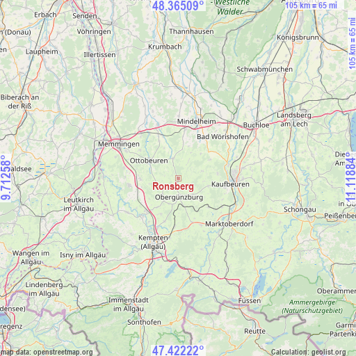
Ronsberg GPS coordinates[2]
47° 53' 44.88" North, 10° 24' 56.556" East
| Map corner | latitude | longitude |
|---|---|---|
| Upper-left | 48.36509°, | 9.71258° |
| Center: | 47.8958°, | 10.41571° |
| Lower-right: | 47.42222°, | 11.11884° |
| Map W x H: | 104.8×104.8 km | = 65.1×65.1mi |
| max Lat: | 55.01917° ⇑96.7% North |
| Ronsberg: | 47.8958° |
| min Lat: | ⇓3.3% South 47.40724° |
| min Long | Ronsberg | max Long |
| 5.92978° | 10.41571° | 14.98853° |
| W 57.3%⇐ | ⇒42.7% E |
Elevation
Elevation of Ronsberg is 696 m = 2283 ft, and this is 446.9 m = 1466 ft above average elevation for this country.
| Max E: |
1256 m = 4121 ft | 2.3% |
| Ronsberg | 696 m 2283 ft | |
| Avg. | 249.1 m = 817 ft | |
Min E: |
-5 m = -16 ft | 97.7% |
See also: Germany elevation on elevation.city.
Geographical zone
Ronsberg is located in North temperate zone (between Tropic of Cancer and the Arctic Circle). Distance of this North polar circle is 2075.7 km =1289.8 mi to North.| Distance of | km | miles | from Ronsberg |
|---|---|---|---|
| North Pole | 4681.5 | 2908.9 | to North |
| Arctic Circle | 2075.7 | 1289.8 | to North |
| Tropic Cancer | 2719.6 | 1689.9 | to South |
| Equator | 5325.5 | 3309.1 | to South |


Nearby cities:
15 places around Ronsberg: (largest is in red/bold)
• Aitrang
12.4 km =7.7 mi,  135°
135°
• Baisweil
10.7 km =6.6 mi,  59°
59°
• Böhen
8.7 km =5.4 mi,  260°
260°
• Eggenthal
7.9 km =4.9 mi,  72°
72°
• Friesenried
9.2 km =5.7 mi,  104°
104°
• Günzach
8 km =5 mi,  169°
169°
• Haldenwang
11.7 km =7.3 mi,  204°
204°
• Irsee
11.7 km =7.3 mi,  83°
83°
• Markt Rettenbach
5.9 km =3.7 mi,  345°
345°
• Obergünzburg
5.6 km =3.5 mi,  178°
178°
• Ottobeuren
10 km =6.2 mi,  300°
300°
• Unteregg
8.7 km =5.4 mi,  25°
25°
• Untrasried
7.4 km =4.6 mi, 199°
• Wald
12.1 km =7.5 mi,  314°
314°
• Wolfertschwenden
11.1 km =6.9 mi,  268°
268°
Sources, notices
• [Note1] Compared only with cities in Germany existing in our database
• [Src1] Map data: © OpenStreetMap contributors (CC-BY-SA)
• [Src2] Other city data from geonames.org with taken over terms of usage.
• [Src3] Geographical zone / Annual Mean Temperature by Robert A. Rohde @ Wikipedia
