Böhen geodata
Böhen (Bavaria) is a seat of a fourth-order administrative division; located in Germany in Europe/Berlin (GMT+2) time zone. With population of 681 people, there are 8411 cities with bigger population in this country. Compared to other cities in Germany, 96.9% of cities are located further ↑North; 55.3% of cities are located further ←West and 98.9% of cities have lower elevation than Böhen. Note1
Administrative division(s):
- Level 1: Bavaria
- Level 2: Swabia
- Level 3: Landkreis Unterallgäu
- Level 4: Böhen


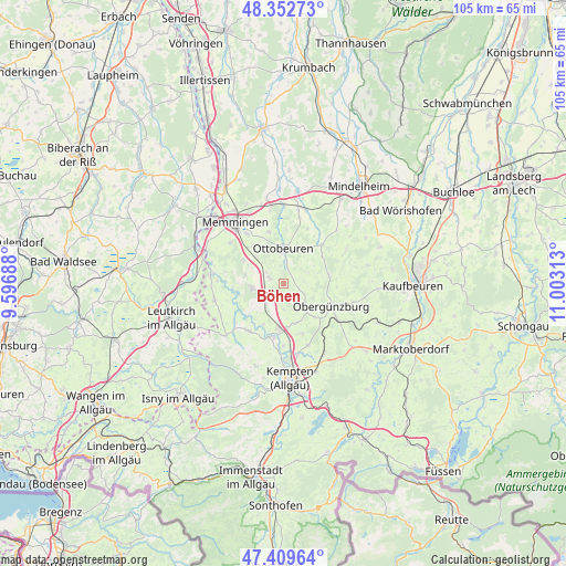
Böhen GPS coordinates[2]
47° 52' 59.988" North, 10° 18' 0" East
| Map corner | latitude | longitude |
|---|---|---|
| Upper-left | 48.35273°, | 9.59688° |
| Center: | 47.88333°, | 10.3° |
| Lower-right: | 47.40964°, | 11.00313° |
| Map W x H: | 104.9×104.9 km | = 65.2×65.2mi |
| max Lat: | 55.01917° ⇑96.9% North |
| Böhen: | 47.88333° |
| min Lat: | ⇓3.1% South 47.40724° |
| min Long | Böhen | max Long |
| 5.92978° | 10.3° | 14.98853° |
| W 55.3%⇐ | ⇒44.7% E |
Elevation
Elevation of Böhen is 768 m = 2520 ft, and this is 518.9 m = 1702 ft above average elevation for this country.
| Max E: |
1256 m = 4121 ft | 1.1% |
| Böhen | 768 m 2520 ft | |
| Avg. | 249.1 m = 817 ft | |
Min E: |
-5 m = -16 ft | 98.9% |
See also: Germany elevation on elevation.city.
Geographical zone
Böhen is located in North temperate zone (between Tropic of Cancer and the Arctic Circle). Distance of this North polar circle is 2077 km =1290.6 mi to North.| Distance of | km | miles | from Böhen |
|---|---|---|---|
| North Pole | 4682.9 | 2909.8 | to North |
| Arctic Circle | 2077 | 1290.6 | to North |
| Tropic Cancer | 2718.2 | 1689 | to South |
| Equator | 5324.1 | 3308.2 | to South |


Nearby cities:
15 places around Böhen: (largest is in red/bold)
• Altusried
10.9 km =6.8 mi,  215°
215°
• Dietmannsried
8.4 km =5.2 mi,  185°
185°
• Haldenwang
10 km =6.2 mi,  158°
158°
• Hawangen
9.6 km =6 mi,  344°
344°
• Kronburg
10.9 km =6.8 mi,  282°
282°
• Lachen
8.3 km =5.2 mi,  327°
327°
• Lauben
11.1 km =6.9 mi,  180°
180°
• Markt Rettenbach
10.1 km =6.3 mi,  45°
45°
• Obergünzburg
9.8 km =6.1 mi,  115°
115°
• Ottobeuren
6.4 km =4 mi,  359°
359°
• Ronsberg
8.7 km =5.4 mi,  80°
80°
• Untrasried
8.3 km =5.2 mi,  131°
131°
• Wald
9.9 km =6.2 mi,  0°
0°
• Wolfertschwenden
2.7 km =1.7 mi,  294°
294°
• Woringen
8.3 km =5.2 mi,  296°
296°
Sources, notices
• [Note1] Compared only with cities in Germany existing in our database
• [Src1] Map data: © OpenStreetMap contributors (CC-BY-SA)
• [Src2] Other city data from geonames.org with taken over terms of usage.
• [Src3] Geographical zone / Annual Mean Temperature by Robert A. Rohde @ Wikipedia
