Roes geodata
Roes (Rheinland-Pfalz) is a seat of a fourth-order administrative division; located in Germany in Europe/Berlin (GMT+2) time zone. With population of 574 people, there are 8953 cities with bigger population in this country. Compared to other cities in Germany, 58.1% of cities are located further ↑North; 90.6% of cities are located further →East and 65.8% of cities have lower elevation than Roes. Note1


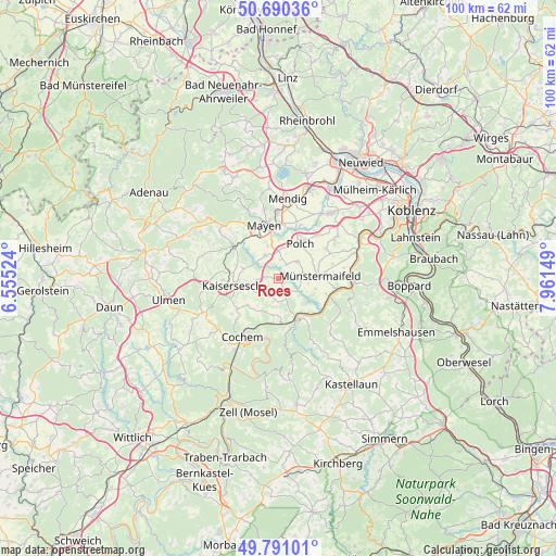
Roes GPS coordinates[2]
50° 14' 34.116" North, 7° 15' 30.096" East
| Map corner | latitude | longitude |
|---|---|---|
| Upper-left | 50.69036°, | 6.55524° |
| Center: | 50.24281°, | 7.25836° |
| Lower-right: | 49.79101°, | 7.96149° |
| Map W x H: | 100×100 km | = 62.1×62.1mi |
| max Lat: | 55.01917° ⇑58.1% North |
| Roes: | 50.24281° |
| min Lat: | ⇓41.9% South 47.40724° |
| min Long | Roes | max Long |
| 5.92978° | 7.25836° | 14.98853° |
| W 9.4%⇐ | ⇒90.6% E |
Elevation
Elevation of Roes is 327 m = 1073 ft, and this is 77.9 m = 256 ft above average elevation for this country.
| Max E: |
1256 m = 4121 ft | 34.2% |
| Roes | 327 m 1073 ft | |
| Avg. | 249.1 m = 817 ft | |
Min E: |
-5 m = -16 ft | 65.8% |
See also: Germany elevation on elevation.city.
Geographical zone
Roes is located in North temperate zone (between Tropic of Cancer and the Arctic Circle). Distance of this North polar circle is 1814.7 km =1127.6 mi to North.| Distance of | km | miles | from Roes |
|---|---|---|---|
| North Pole | 4420.6 | 2746.8 | to North |
| Arctic Circle | 1814.7 | 1127.6 | to North |
| Tropic Cancer | 2980.6 | 1852.1 | to South |
| Equator | 5586.5 | 3471.3 | to South |


Nearby cities:
15 places around Roes: (largest is in red/bold)
• Binningen
4.1 km =2.5 mi,  192°
192°
• Brachtendorf
2.1 km =1.3 mi,  239°
239°
• Brohl
3 km =1.9 mi,  150°
150°
• Dünfus
3.4 km =2.1 mi,  211°
211°
• Einig
4.8 km =3 mi,  21°
21°
• Gamlen
4.3 km =2.7 mi,  255°
255°
• Gering
4.5 km =2.8 mi,  7°
7°
• Kaifenheim
2.3 km =1.4 mi,  276°
276°
• Kehrig
5.4 km =3.4 mi,  326°
326°
• Kollig
3.2 km =2 mi,  33°
33°
• Mertloch
4.6 km =2.9 mi,  50°
50°
• Möntenich
3.8 km =2.4 mi,  129°
129°
• Naunheim
4.2 km =2.6 mi,  79°
79°
• Pillig
3.8 km =2.4 mi,  96°
96°
• Zettingen
4.3 km =2.7 mi, 255°
Sources, notices
• [Note1] Compared only with cities in Germany existing in our database
• [Src1] Map data: © OpenStreetMap contributors (CC-BY-SA)
• [Src2] Other city data from geonames.org with taken over terms of usage.
• [Src3] Geographical zone / Annual Mean Temperature by Robert A. Rohde @ Wikipedia
