Möntenich geodata
Möntenich (Rheinland-Pfalz) is a seat of a fourth-order administrative division; located in Germany in Europe/Berlin (GMT+2) time zone. With population of 154 people, there are 10672 cities with bigger population in this country. Compared to other cities in Germany, 58.6% of cities are located further ↑North; 90% of cities are located further →East and 50.1% of cities have lower elevation than Möntenich. Note1
Administrative division(s):
- Level 1: Rheinland-Pfalz
- Level 3: Landkreis Cochem-Zell
- Level 4: Möntenich


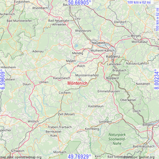
Möntenich GPS coordinates[2]
50° 13' 16.644" North, 7° 17' 57.156" East
| Map corner | latitude | longitude |
|---|---|---|
| Upper-left | 50.66905°, | 6.59609° |
| Center: | 50.22129°, | 7.29921° |
| Lower-right: | 49.76929°, | 8.00234° |
| Map W x H: | 100×100 km | = 62.1×62.1mi |
| max Lat: | 55.01917° ⇑58.6% North |
| Möntenich: | 50.22129° |
| min Lat: | ⇓41.4% South 47.40724° |
| min Long | Möntenich | max Long |
| 5.92978° | 7.29921° | 14.98853° |
| W 10%⇐ | ⇒90% E |
Elevation
Elevation of Möntenich is 226 m = 741 ft, and this is 23.1 m = 76 ft below average elevation for this country.
| Max E: |
1256 m = 4121 ft | 49.9% |
| Avg. | 249.1 m = 817 ft | |
| Möntenich | 226 m = 741 ft | |
Min E: |
-5 m = -16 ft | 50.1% |
See also: Germany elevation on elevation.city.
Geographical zone
Möntenich is located in North temperate zone (between Tropic of Cancer and the Arctic Circle). Distance of this North polar circle is 1817.1 km =1129.1 mi to North.| Distance of | km | miles | from Möntenich |
|---|---|---|---|
| North Pole | 4423 | 2748.3 | to North |
| Arctic Circle | 1817.1 | 1129.1 | to North |
| Tropic Cancer | 2978.2 | 1850.6 | to South |
| Equator | 5584.1 | 3469.8 | to South |


Nearby cities:
15 places around Möntenich: (largest is in red/bold)
• Binningen
4.1 km =2.5 mi,  246°
246°
• Brachtendorf
4.9 km =3 mi,  285°
285°
• Brieden
4.8 km =3 mi,  208°
208°
• Brohl
1.4 km =0.9 mi,  260°
260°
• Dünfus
4.7 km =2.9 mi, 263°
• Kaifenheim
5.8 km =3.6 mi,  296°
296°
• Kollig
5.2 km =3.2 mi,  347°
347°
• Mertloch
5.4 km =3.4 mi,  6°
6°
• Müden
5 km =3.1 mi,  144°
144°
• Münstermaifeld
5.3 km =3.3 mi,  58°
58°
• Naunheim
3.4 km =2.1 mi,  21°
21°
• Pillig
2.2 km =1.4 mi, 23°
• Roes
3.8 km =2.4 mi,  309°
309°
• Treis-Karden
5.5 km =3.4 mi,  177°
177°
• Wierschem
3.8 km =2.4 mi,  82°
82°
Sources, notices
• [Note1] Compared only with cities in Germany existing in our database
• [Src1] Map data: © OpenStreetMap contributors (CC-BY-SA)
• [Src2] Other city data from geonames.org with taken over terms of usage.
• [Src3] Geographical zone / Annual Mean Temperature by Robert A. Rohde @ Wikipedia
