Rödinghausen geodata
Rödinghausen (North Rhine-Westphalia) is a seat of a fourth-order administrative division; located in Germany in Europe/Berlin (GMT+2) time zone. With population of 10,101 people, there are 1622 cities with bigger population in this country. Compared to other cities in Germany, 74.6% of cities are located further ↓South; 71.2% of cities are located further →East and 62.5% of cities have higher elevation than Rödinghausen. Note1
Administrative division(s):
- Level 1: North Rhine-Westphalia
- Level 2: Regierungsbezirk Detmold
- Level 3: Kreis Herford
- Level 4: Rödinghausen


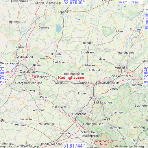
Rödinghausen GPS coordinates[2]
52° 15' 0" North, 8° 28' 59.988" East
| Map corner | latitude | longitude |
|---|---|---|
| Upper-left | 52.67838°, | 7.78021° |
| Center: | 52.25°, | 8.48333° |
| Lower-right: | 51.81744°, | 9.18646° |
| Map W x H: | 95.7×95.7 km | = 59.5×59.5mi |
| max Lat: | 55.01917° ⇑25.4% North |
| Rödinghausen: | 52.25° |
| min Lat: | ⇓74.6% South 47.40724° |
| min Long | Rödinghausen | max Long |
| 5.92978° | 8.48333° | 14.98853° |
| W 28.8%⇐ | ⇒71.2% E |
Elevation
Elevation of Rödinghausen is 135 m = 443 ft, and this is 114.1 m = 374 ft below average elevation for this country.
| Max E: |
1256 m = 4121 ft | 62.5% |
| Avg. | 249.1 m = 817 ft | |
| Rödinghausen | 135 m = 443 ft | |
Min E: |
-5 m = -16 ft | 37.5% |
See also: Germany elevation on elevation.city.
Geographical zone
Rödinghausen is located in North temperate zone (between Tropic of Cancer and the Arctic Circle). Distance of this North polar circle is 1591.5 km =988.9 mi to North.| Distance of | km | miles | from Rödinghausen |
|---|---|---|---|
| North Pole | 4197.4 | 2608.1 | to North |
| Arctic Circle | 1591.5 | 988.9 | to North |
| Tropic Cancer | 3203.7 | 1990.7 | to South |
| Equator | 5809.7 | 3610 | to South |


Nearby cities:
15 places around Rödinghausen: (largest is in red/bold)
• Bad Essen
12.6 km =7.8 mi,  305°
305°
• Bad Holzhausen
5.8 km =3.6 mi,  40°
40°
• Bohmte
17.2 km =10.7 mi,  318°
318°
• Bünde
9.1 km =5.7 mi,  129°
129°
• Enger
13.2 km =8.2 mi,  157°
157°
• Hiddenhausen
13 km =8.1 mi,  135°
135°
• Hüllhorst
13 km =8.1 mi,  73°
73°
• Kirchlengern
11.6 km =7.2 mi,  118°
118°
• Löhne
15.8 km =9.8 mi, 115°
• Lübbecke
10.9 km =6.8 mi,  54°
54°
• Melle
11.2 km =7 mi,  241°
241°
• Neuenkirchen
14.1 km =8.8 mi,  207°
207°
• Obernbeck
16 km =9.9 mi,  109°
109°
• Preußisch Oldendorf
6.3 km =3.9 mi,  6°
6°
• Spenge
12.2 km =7.6 mi,  179°
179°
Sources, notices
• [Note1] Compared only with cities in Germany existing in our database
• [Src1] Map data: © OpenStreetMap contributors (CC-BY-SA)
• [Src2] Other city data from geonames.org with taken over terms of usage.
• [Src3] Geographical zone / Annual Mean Temperature by Robert A. Rohde @ Wikipedia
