Melle geodata
Melle (Lower Saxony) is a populated place; located in Germany in Europe/Berlin (GMT+2) time zone. With population of 46,514 people, there are 250 cities with bigger population in this country. Compared to other cities in Germany, 74.1% of cities are located further ↓South; 72.6% of cities are located further →East and 71.3% of cities have higher elevation than Melle. Note1


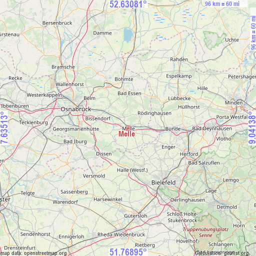
Melle GPS coordinates[2]
52° 12' 7.092" North, 8° 20' 17.736" East
| Map corner | latitude | longitude |
|---|---|---|
| Upper-left | 52.63081°, | 7.63513° |
| Center: | 52.20197°, | 8.33826° |
| Lower-right: | 51.76895°, | 9.04138° |
| Map W x H: | 95.8×95.8 km | = 59.5×59.5mi |
| max Lat: | 55.01917° ⇑25.9% North |
| Melle: | 52.20197° |
| min Lat: | ⇓74.1% South 47.40724° |
| min Long | Melle | max Long |
| 5.92978° | 8.33826° | 14.98853° |
| W 27.4%⇐ | ⇒72.6% E |
Elevation
Elevation of Melle is 82 m = 269 ft, and this is 167.1 m = 548 ft below average elevation for this country.
| Max E: |
1256 m = 4121 ft | 71.3% |
| Avg. | 249.1 m = 817 ft | |
| Melle | 82 m = 269 ft | |
Min E: |
-5 m = -16 ft | 28.7% |
See also: Melle elevation on elevation.city.
Geographical zone
Melle is located in North temperate zone (between Tropic of Cancer and the Arctic Circle). Distance of this North polar circle is 1596.9 km =992.3 mi to North.| Distance of | km | miles | from Melle |
|---|---|---|---|
| North Pole | 4202.7 | 2611.4 | to North |
| Arctic Circle | 1596.9 | 992.3 | to North |
| Tropic Cancer | 3198.4 | 1987.4 | to South |
| Equator | 5804.3 | 3606.6 | to South |


Nearby cities:
15 places around Melle: (largest is in red/bold)
• Bad Essen
12.8 km =8 mi,  358°
358°
• Bad Holzhausen
16.8 km =10.4 mi,  54°
54°
• Bad Rothenfelde
15.1 km =9.4 mi,  230°
230°
• Bissendorf
12.2 km =7.6 mi,  286°
286°
• Borgholzhausen
11.2 km =7 mi,  192°
192°
• Bünde
16.9 km =10.5 mi,  91°
91°
• Dissen
13.5 km =8.4 mi,  224°
224°
• Enger
16.4 km =10.2 mi,  114°
114°
• Halle
15.9 km =9.9 mi,  174°
174°
• Hilter
15 km =9.3 mi,  240°
240°
• Neuenkirchen
7.9 km =4.9 mi,  154°
154°
• Preußisch Oldendorf
15.7 km =9.8 mi,  42°
42°
• Rödinghausen
11.2 km =7 mi,  61°
61°
• Spenge
12.1 km =7.5 mi,  124°
124°
• Werther
14.8 km =9.2 mi,  158°
158°
Sources, notices
• [Note1] Compared only with cities in Germany existing in our database
• [Src1] Map data: © OpenStreetMap contributors (CC-BY-SA)
• [Src2] Other city data from geonames.org with taken over terms of usage.
• [Src3] Geographical zone / Annual Mean Temperature by Robert A. Rohde @ Wikipedia
