Preußisch Oldendorf geodata
Preußisch Oldendorf (North Rhine-Westphalia) is a populated place; located in Germany in Europe/Berlin (GMT+2) time zone. With population of 13,447 people, there are 1192 cities with bigger population in this country. Compared to other cities in Germany, 75.2% of cities are located further ↓South; 71.2% of cities are located further →East and 75.5% of cities have higher elevation than Preußisch Oldendorf. Note1
Administrative division(s):
- Level 1: North Rhine-Westphalia
- Level 2: Regierungsbezirk Detmold
- Level 3: Kreis Minden-Lübbecke
- Level 4: Preußisch Oldendorf


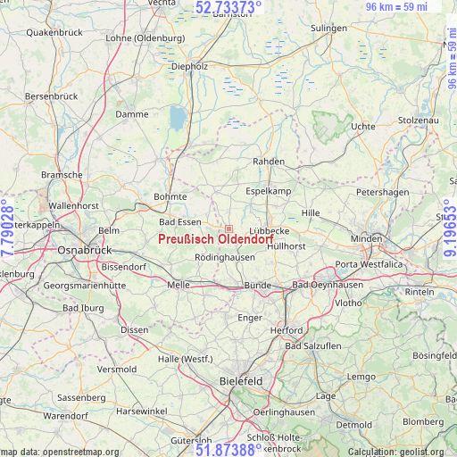
Preußisch Oldendorf GPS coordinates[2]
52° 18' 21.204" North, 8° 29' 36.276" East
| Map corner | latitude | longitude |
|---|---|---|
| Upper-left | 52.73373°, | 7.79028° |
| Center: | 52.30589°, | 8.49341° |
| Lower-right: | 51.87388°, | 9.19653° |
| Map W x H: | 95.6×95.6 km | = 59.4×59.4mi |
| max Lat: | 55.01917° ⇑24.8% North |
| Preußisch Oldendorf: | 52.30589° |
| min Lat: | ⇓75.2% South 47.40724° |
| min Long | Preußisch Olde | max Long |
| 5.92978° | 8.49341° | 14.98853° |
| W 28.8%⇐ | ⇒71.2% E |
Elevation
Elevation of Preußisch Oldendorf is 61 m = 200 ft, and this is 188.1 m = 617 ft below average elevation for this country.
| Max E: |
1256 m = 4121 ft | 75.5% |
| Avg. | 249.1 m = 817 ft | |
| Preußisch Oldendorf | 61 m = 200 ft | |
Min E: |
-5 m = -16 ft | 24.5% |
See also: Germany elevation on elevation.city.
Geographical zone
Preußisch Oldendorf is located in North temperate zone (between Tropic of Cancer and the Arctic Circle). Distance of this North polar circle is 1585.3 km =985.1 mi to North.| Distance of | km | miles | from Preußisch Oldendorf |
|---|---|---|---|
| North Pole | 4191.2 | 2604.3 | to North |
| Arctic Circle | 1585.3 | 985.1 | to North |
| Tropic Cancer | 3210 | 1994.6 | to South |
| Equator | 5815.9 | 3613.8 | to South |


Nearby cities:
15 places around Preußisch Oldendorf: (largest is in red/bold)
• Bad Essen
10.9 km =6.8 mi,  276°
276°
• Bad Holzhausen
3.6 km =2.2 mi,  119°
119°
• Bohmte
13.8 km =8.6 mi,  299°
299°
• Bünde
13.5 km =8.4 mi,  152°
152°
• Espelkamp
12.2 km =7.6 mi,  45°
45°
• Hiddenhausen
17.6 km =10.9 mi, 151°
• Hille
17.7 km =11 mi,  80°
80°
• Hüllhorst
12 km =7.5 mi,  102°
102°
• Kirchlengern
15.1 km =9.4 mi,  141°
141°
• Laar
17.2 km =10.7 mi,  288°
288°
• Lübbecke
8.2 km =5.1 mi,  89°
89°
• Melle
15.7 km =9.8 mi,  222°
222°
• Rahden
16.4 km =10.2 mi,  29°
29°
• Rödinghausen
6.3 km =3.9 mi,  186°
186°
• Stemshorn
18.2 km =11.3 mi,  331°
331°
Sources, notices
• [Note1] Compared only with cities in Germany existing in our database
• [Src1] Map data: © OpenStreetMap contributors (CC-BY-SA)
• [Src2] Other city data from geonames.org with taken over terms of usage.
• [Src3] Geographical zone / Annual Mean Temperature by Robert A. Rohde @ Wikipedia
