Rinteln geodata
Rinteln (Lower Saxony) is a populated place; located in Germany in Europe/Berlin (GMT+2) time zone. With population of 27,843 people, there are 509 cities with bigger population in this country. Compared to other cities in Germany, 73.9% of cities are located further ↓South; 64.3% of cities are located further →East and 75.8% of cities have higher elevation than Rinteln. Note1


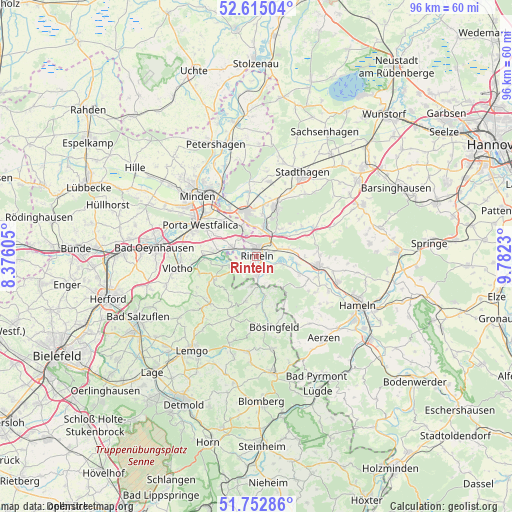
Rinteln GPS coordinates[2]
52° 11' 9.744" North, 9° 4' 45.012" East
| Map corner | latitude | longitude |
|---|---|---|
| Upper-left | 52.61504°, | 8.37605° |
| Center: | 52.18604°, | 9.07917° |
| Lower-right: | 51.75286°, | 9.7823° |
| Map W x H: | 95.9×95.9 km | = 59.6×59.6mi |
| max Lat: | 55.01917° ⇑26.1% North |
| Rinteln: | 52.18604° |
| min Lat: | ⇓73.9% South 47.40724° |
| min Long | Rinteln | max Long |
| 5.92978° | 9.07917° | 14.98853° |
| W 35.7%⇐ | ⇒64.3% E |
Elevation
Elevation of Rinteln is 60 m = 197 ft, and this is 189.1 m = 620 ft below average elevation for this country.
| Max E: |
1256 m = 4121 ft | 75.8% |
| Avg. | 249.1 m = 817 ft | |
| Rinteln | 60 m = 197 ft | |
Min E: |
-5 m = -16 ft | 24.2% |
See also: Germany elevation on elevation.city.
Geographical zone
Rinteln is located in North temperate zone (between Tropic of Cancer and the Arctic Circle). Distance of this North polar circle is 1598.6 km =993.3 mi to North.| Distance of | km | miles | from Rinteln |
|---|---|---|---|
| North Pole | 4204.5 | 2612.6 | to North |
| Arctic Circle | 1598.6 | 993.3 | to North |
| Tropic Cancer | 3196.6 | 1986.3 | to South |
| Equator | 5802.5 | 3605.5 | to South |


Nearby cities:
15 places around Rinteln: (largest is in red/bold)
• Ahnsen
7.8 km =4.8 mi,  10°
10°
• Bad Eilsen
6.4 km =4 mi, 11°
• Buchholz
5.6 km =3.5 mi,  36°
36°
• Bückeburg
8.5 km =5.3 mi,  346°
346°
• Heeßen
5.3 km =3.3 mi, 12°
• Helpsen
14.2 km =8.8 mi, 10°
• Hespe
16.1 km =10 mi, 7°
• Hessisch Oldendorf
11.7 km =7.3 mi,  97°
97°
• Luhden
4.5 km =2.8 mi, 11°
• Nienstädt
13.2 km =8.2 mi,  26°
26°
• Obernkirchen
10.2 km =6.3 mi,  19°
19°
• Porta Westfalica
12.1 km =7.5 mi,  293°
293°
• Rehren
11.7 km =7.3 mi,  63°
63°
• Seggebruch
12.8 km =8 mi,  4°
4°
• Vlotho
15.1 km =9.4 mi,  261°
261°
Sources, notices
• [Note1] Compared only with cities in Germany existing in our database
• [Src1] Map data: © OpenStreetMap contributors (CC-BY-SA)
• [Src2] Other city data from geonames.org with taken over terms of usage.
• [Src3] Geographical zone / Annual Mean Temperature by Robert A. Rohde @ Wikipedia
