Obernkirchen geodata
Obernkirchen (Lower Saxony) is a populated place; located in Germany in Europe/Berlin (GMT+2) time zone. With population of 10,120 people, there are 1619 cities with bigger population in this country. Compared to other cities in Germany, 74.9% of cities are located further ↓South; 63.5% of cities are located further →East and 64.8% of cities have higher elevation than Obernkirchen. Note1
Administrative division(s):
- Level 1: Lower Saxony
- Level 3: Landkreis Schaumburg
- Level 4: Obernkirchen


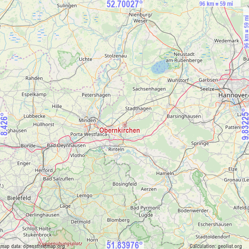
Obernkirchen GPS coordinates[2]
52° 16' 19.56" North, 9° 7' 44.832" East
| Map corner | latitude | longitude |
|---|---|---|
| Upper-left | 52.70027°, | 8.426° |
| Center: | 52.2721°, | 9.12912° |
| Lower-right: | 51.83976°, | 9.83225° |
| Map W x H: | 95.7×95.7 km | = 59.5×59.5mi |
| max Lat: | 55.01917° ⇑25.1% North |
| Obernkirchen: | 52.2721° |
| min Lat: | ⇓74.9% South 47.40724° |
| min Long | Obernkirchen | max Long |
| 5.92978° | 9.12912° | 14.98853° |
| W 36.5%⇐ | ⇒63.5% E |
Elevation
Elevation of Obernkirchen is 121 m = 397 ft, and this is 128.1 m = 420 ft below average elevation for this country.
| Max E: |
1256 m = 4121 ft | 64.8% |
| Avg. | 249.1 m = 817 ft | |
| Obernkirchen | 121 m = 397 ft | |
Min E: |
-5 m = -16 ft | 35.2% |
See also: Germany elevation on elevation.city.
Geographical zone
Obernkirchen is located in North temperate zone (between Tropic of Cancer and the Arctic Circle). Distance of this North polar circle is 1589.1 km =987.4 mi to North.| Distance of | km | miles | from Obernkirchen |
|---|---|---|---|
| North Pole | 4194.9 | 2606.6 | to North |
| Arctic Circle | 1589.1 | 987.4 | to North |
| Tropic Cancer | 3206.2 | 1992.2 | to South |
| Equator | 5812.1 | 3611.5 | to South |


Nearby cities:
15 places around Obernkirchen: (largest is in red/bold)
• Ahnsen
2.7 km =1.7 mi,  224°
224°
• Bad Eilsen
3.9 km =2.4 mi,  212°
212°
• Buchholz
5.1 km =3.2 mi,  181°
181°
• Bückeburg
5.6 km =3.5 mi,  256°
256°
• Heeßen
5 km =3.1 mi, 206°
• Helpsen
4.4 km =2.7 mi,  349°
349°
• Hespe
6.6 km =4.1 mi, 347°
• Luhden
5.8 km =3.6 mi, 205°
• Meerbeck
7.9 km =4.9 mi,  10°
10°
• Niedernwöhren
9 km =5.6 mi, 8°
• Nienstädt
3.3 km =2.1 mi,  46°
46°
• Nordsehl
9.4 km =5.8 mi,  23°
23°
• Rehren
8.3 km =5.2 mi,  121°
121°
• Seggebruch
3.9 km =2.4 mi,  323°
323°
• Stadthagen
7.6 km =4.7 mi,  41°
41°
Sources, notices
• [Note1] Compared only with cities in Germany existing in our database
• [Src1] Map data: © OpenStreetMap contributors (CC-BY-SA)
• [Src2] Other city data from geonames.org with taken over terms of usage.
• [Src3] Geographical zone / Annual Mean Temperature by Robert A. Rohde @ Wikipedia
