Retgendorf geodata
Retgendorf (Mecklenburg-Vorpommern) is a populated place; located in Germany in Europe/Berlin (GMT+2) time zone. With population of 1,187 people, there are 6599 cities with bigger population in this country. Compared to other cities in Germany, 89% of cities are located further ↓South; 74.4% of cities are located further ←West and 80.2% of cities have higher elevation than Retgendorf. Note1
Administrative division(s):
- Level 1: Mecklenburg-Vorpommern
- Level 3: Ludwigslust-Parchim
- Level 4: Dobin am See


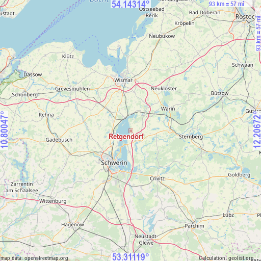
Retgendorf GPS coordinates[2]
53° 43' 45.192" North, 11° 30' 12.924" East
| Map corner | latitude | longitude |
|---|---|---|
| Upper-left | 54.14314°, | 10.80047° |
| Center: | 53.72922°, | 11.50359° |
| Lower-right: | 53.31119°, | 12.20672° |
| Map W x H: | 92.5×92.5 km | = 57.5×57.5mi |
| max Lat: | 55.01917° ⇑11% North |
| Retgendorf: | 53.72922° |
| min Lat: | ⇓89% South 47.40724° |
| min Long | Retgendorf | max Long |
| 5.92978° | 11.50359° | 14.98853° |
| W 74.4%⇐ | ⇒25.6% E |
Elevation
Elevation of Retgendorf is 46 m = 151 ft, and this is 203.1 m = 666 ft below average elevation for this country.
| Max E: |
1256 m = 4121 ft | 80.2% |
| Avg. | 249.1 m = 817 ft | |
| Retgendorf | 46 m = 151 ft | |
Min E: |
-5 m = -16 ft | 19.8% |
See also: Germany elevation on elevation.city.
Geographical zone
Retgendorf is located in North temperate zone (between Tropic of Cancer and the Arctic Circle). Distance of this North polar circle is 1427 km =886.7 mi to North.| Distance of | km | miles | from Retgendorf |
|---|---|---|---|
| North Pole | 4032.9 | 2505.9 | to North |
| Arctic Circle | 1427 | 886.7 | to North |
| Tropic Cancer | 3368.2 | 2092.9 | to South |
| Equator | 5974.1 | 3712.1 | to South |


Nearby cities:
15 places around Retgendorf: (largest is in red/bold)
• Alt Meteln
10.9 km =6.8 mi,  280°
280°
• Bad Kleinen
5.1 km =3.2 mi,  335°
335°
• Brahlstorf
4.9 km =3 mi,  131°
131°
• Cambs
3.9 km =2.4 mi,  156°
156°
• Groß Stieten
10 km =6.2 mi, 339°
• Hohen Viecheln
6.2 km =3.9 mi,  4°
4°
• Jesendorf
10.4 km =6.5 mi,  37°
37°
• Klein Trebbow
8.9 km =5.5 mi,  257°
257°
• Kuhlen
7.2 km =4.5 mi,  97°
97°
• Leezen
7.4 km =4.6 mi,  182°
182°
• Lübstorf
5.9 km =3.7 mi,  266°
266°
• Rubow
5.4 km =3.4 mi,  55°
55°
• Seehof
6.2 km =3.9 mi,  228°
228°
• Ventschow
8.2 km =5.1 mi, 37°
• Zickhusen
6.8 km =4.2 mi,  299°
299°
Sources, notices
• [Note1] Compared only with cities in Germany existing in our database
• [Src1] Map data: © OpenStreetMap contributors (CC-BY-SA)
• [Src2] Other city data from geonames.org with taken over terms of usage.
• [Src3] Geographical zone / Annual Mean Temperature by Robert A. Rohde @ Wikipedia
