Jesendorf geodata
Jesendorf (Mecklenburg-Vorpommern) is a populated place; located in Germany in Europe/Berlin (GMT+2) time zone. With population of 535 people, there are 9166 cities with bigger population in this country. Compared to other cities in Germany, 90.1% of cities are located further ↓South; 75.8% of cities are located further ←West and 78.7% of cities have higher elevation than Jesendorf. Note1
Administrative division(s):
- Level 1: Mecklenburg-Vorpommern
- Level 3: Nordwestmecklenburg
- Level 4: Jesendorf


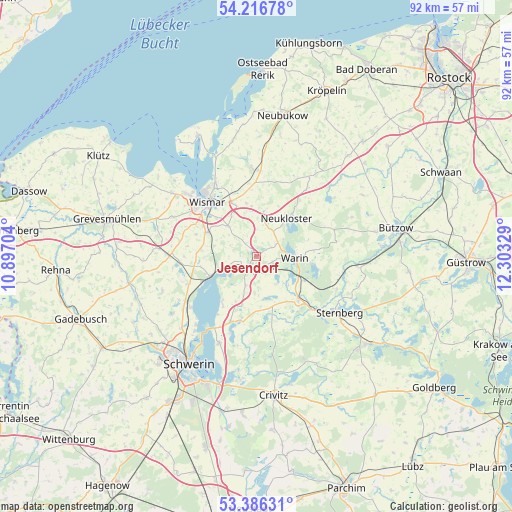
Jesendorf GPS coordinates[2]
53° 48' 12.96" North, 11° 36' 0.576" East
| Map corner | latitude | longitude |
|---|---|---|
| Upper-left | 54.21678°, | 10.89704° |
| Center: | 53.8036°, | 11.60016° |
| Lower-right: | 53.38631°, | 12.30329° |
| Map W x H: | 92.3×92.3 km | = 57.4×57.4mi |
| max Lat: | 55.01917° ⇑9.9% North |
| Jesendorf: | 53.8036° |
| min Lat: | ⇓90.1% South 47.40724° |
| min Long | Jesendorf | max Long |
| 5.92978° | 11.60016° | 14.98853° |
| W 75.8%⇐ | ⇒24.2% E |
Elevation
Elevation of Jesendorf is 51 m = 167 ft, and this is 198.1 m = 650 ft below average elevation for this country.
| Max E: |
1256 m = 4121 ft | 78.7% |
| Avg. | 249.1 m = 817 ft | |
| Jesendorf | 51 m = 167 ft | |
Min E: |
-5 m = -16 ft | 21.3% |
See also: Germany elevation on elevation.city.
Geographical zone
Jesendorf is located in North temperate zone (between Tropic of Cancer and the Arctic Circle). Distance of this North polar circle is 1418.8 km =881.6 mi to North.| Distance of | km | miles | from Jesendorf |
|---|---|---|---|
| North Pole | 4024.7 | 2500.8 | to North |
| Arctic Circle | 1418.8 | 881.6 | to North |
| Tropic Cancer | 3376.5 | 2098.1 | to South |
| Equator | 5982.4 | 3717.3 | to South |


Nearby cities:
15 places around Jesendorf: (largest is in red/bold)
• Bad Kleinen
9.2 km =5.7 mi,  246°
246°
• Brahlstorf
11.8 km =7.3 mi,  193°
193°
• Brüel
10.5 km =6.5 mi,  134°
134°
• Groß Stieten
10 km =6.2 mi,  276°
276°
• Hohen Viecheln
6.2 km =3.9 mi, 250°
• Kuhlen
9.2 km =5.7 mi,  175°
175°
• Lübow
7.4 km =4.6 mi,  317°
317°
• Mecklenburg
10 km =6.2 mi,  295°
295°
• Neukloster
8.9 km =5.5 mi,  39°
39°
• Retgendorf
10.4 km =6.5 mi,  217°
217°
• Rubow
5.5 km =3.4 mi,  199°
199°
• Sellin
9.1 km =5.7 mi,  3°
3°
• Ventschow
2.2 km =1.4 mi, 216°
• Warin
6.9 km =4.3 mi,  93°
93°
• Zurow
6.8 km =4.2 mi,  7°
7°
Sources, notices
• [Note1] Compared only with cities in Germany existing in our database
• [Src1] Map data: © OpenStreetMap contributors (CC-BY-SA)
• [Src2] Other city data from geonames.org with taken over terms of usage.
• [Src3] Geographical zone / Annual Mean Temperature by Robert A. Rohde @ Wikipedia
